Dizzying Donegal

LENNY ANTONELLI explores the seascapes of Gleann Cholm Cille

Irish Times, 27 October 2012

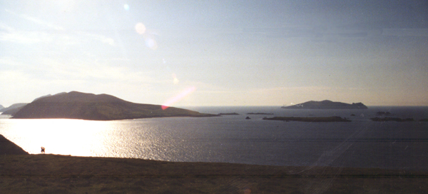
DRIVING IN FROM the bog above, Gleann Cholm Cille appears like a Greenlandic outpost, a scatter of low buildings enclosed by sea and mountain. A web of bog tracks takes you into the hills north of the village – a branch from one leads to an early 19th-century lookout tower, on the 220m cliffs at Glen Head.

Local teacher Thomas McGinley found this height too great to comprehend the sea below. “Both vision and hearing fail . . . at this awful altitude,” he wrote.  McGinley walked this coast in the 19th century, documenting its wildlife and history. The Derry Journal published his notes weekly under the pen-name Kinnfaela, and later collected them in a book The Cliff Scenery of South Western Donegal.

I abandon the trail at the tower and follow the coast. Soon the cliffs indent sharply and the ground drops steeply to a small valley – move inland to cross the valley safely and rejoin the cliffs on the other side.

Up ahead the coast cuts out to sea at a right angle – this is the Sturrall, a vertical headland where locals once picked edible rock samphire, McGinley wrote. Some even descended the cliff to gather seaweed on the shore far below.

His book tells the story of a rector’s son who planned to swipe eggs from an eagle’s nest on the Sturrall. Locals warned against it, but this hardened the lad’s ambition, and he raved about the idea in his sleep. One night he sleepwalked up to the cliffs and strode out the Sturrall through wind and rain. The next morning he told his mother he had dreamt of robbing the nest, and she promptly handed him the eggs he’d brought back in the night.

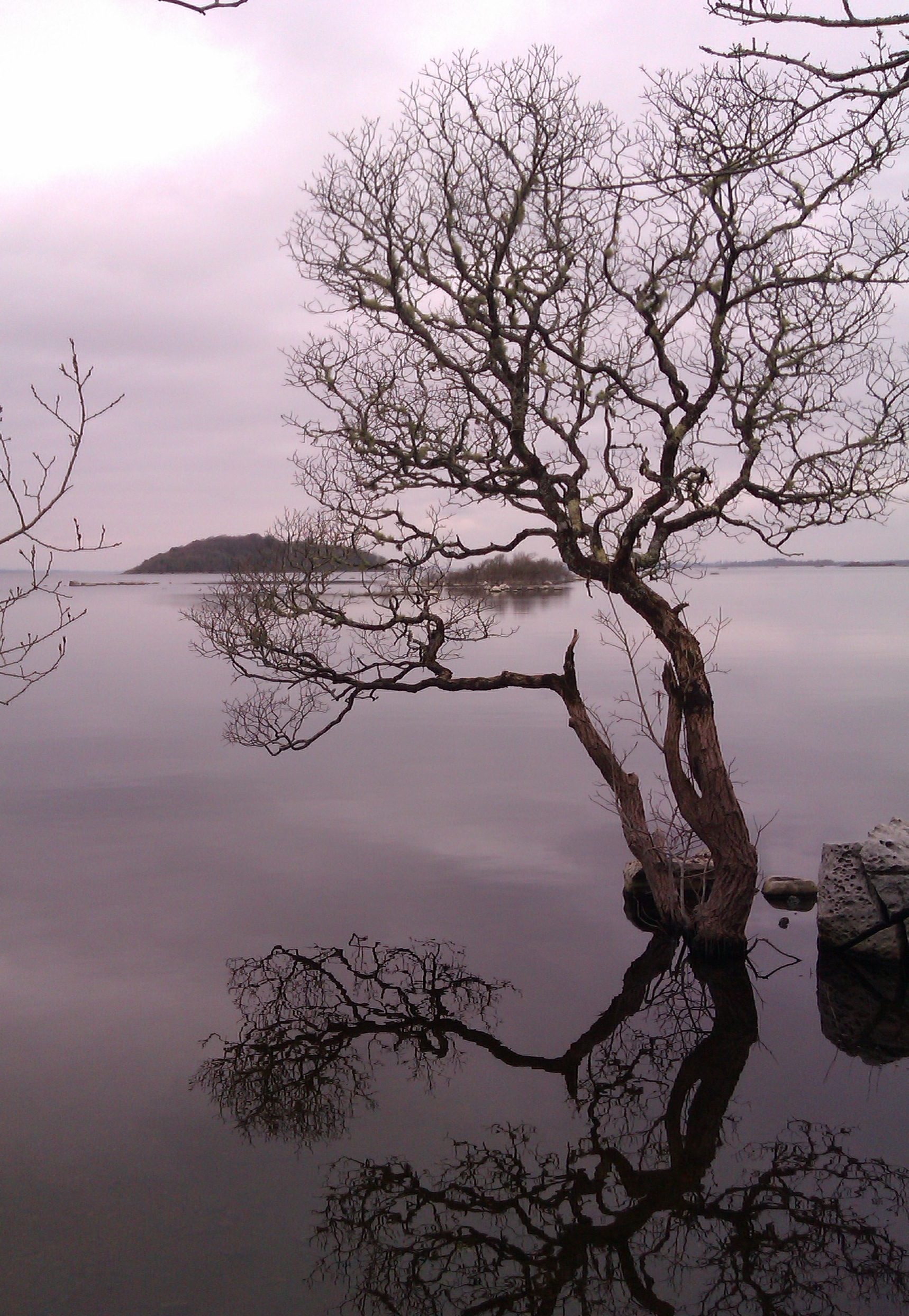
Following the cliffs, the terrain shifts from dry heather to muddy bog to a forest of dead ferns. Two choughs let out laser-like calls above me – these red-billed crows live along our western coasts, but their numbers are declining.

Soon a track leads down to the shore at Port, a ruined settlement that was home to a few shepherds during the 19th century. Nearby in 1870 a storm sunk the Sydney, a cargo ship taking timber from Quebec to Scotland. Four of the 19 dead are buried at Port.

I climb up Port Hill along the cliffs for a view of Tormore, Ireland’s highest sea stack. Local folklorist Seán O’Heochaidh told a story of the stack: Jack Mór climbed it to hunt seabirds during the famine. He met another man on the same mission, and both filled their bags with birds. But Jack Mór weakened on his way down and couldn’t carry on. The other man went for help, but a great storm blew in. Jack Mór was stranded for a fortnight. When his rescuers arrived, there was nothing left of Jack but his bones. It was said these could still be seen on the side of Tormore 70 years later.

Daylight was against me and it was time to head back down to Port, where the bog track offers a different return route to Gleann Cholm Cille. Since setting out, the valleys had grown progressively more remote: first Gleann Cholm Cille itself, then the backwater of Port, and now ahead of me was Glenlough, with ruined cottages that no road reaches.

The American painter, Rockwell Kent, stayed at Glenlough in 1926 while painting this coast. The Welsh poet, Dylan Thomas, spent a summer there too, trying to wean himself off alcohol by walking and writing. But the black nights and isolation got to him, and in letters to a friend he recalled encounters with Count Antigarlic, “a strange Hungarian gentleman . . . coming down the hill in a cloak lined with spiders”. The local poitín may have gone to his head.

Map: Ordnance Survey Ireland, Discovery Series, Sheet 10.

Start finish: We parked in the townland of Beefan, just north of the village, joining the bog track around grid reference G 524 858.

Route: My walk followed sections of various official trails, starting on the Tower Loop. The bog track from Port back to Glencolmcille is part of the long distance Slí Cholmcille, and also joins the local Drum Loop. Seeirishtrails.iefor details.

There is a map board of local loops at the walking centre in the village. Do not attempt a shortcut back to the start point by going off trail across Beefan and Garveross Mountain – its south face is extremely steep.

Suitability: Inexperienced walkers should keep to the marked trails and avoid open mountain and cliff. Utmost care and attention required. Stay inside the intermittent fence. Map, warm clothes, good boots, rain gear, packed lunch, food and water needed. Compass and navigation skills required if heading off trail.

Time: Six to seven hours for my route, or four for both local loops.

Distance: My route was about 19km. Combing both local loops is 13km.

Services: Shop, food and accommodation in Glencolmcille.

The Blasket Islands

Irish Times, 29 September 2012

LENNY ANTONELLI walks Great Blasket and its lesser-known smaller cousins

OF ALL IRISH islands, Inishnabro offers its rare visitor the grandest entrance. We climb from our ferry into a dinghy and search for a landing spot among the steep rock. Suddenly a sea arch appears, and our boatman steers through it to a hidden cove. We hop out onto the wet rock and up a steep gully to the grassy slopes above.

Inishnabro is one of the Blasket Islands, those last half-drowned scraps of Ireland before the open Atlantic. Much has been written about Great Blasket, home to authors Peig Sayers and Muiris Ó Súilleabháin, which was evacuated in 1953. But little is said of neighbouring islands such as Inishnabro and Inishtooskert.

Without animals to graze it, Inishnabro’s flora seems primeval, a kaleidoscope of colour and texture unseen elsewhere. Its upper slopes are thick with purple heather, spongy sea pink and yellow goldenrod. We hike to the 175m summit, on the north face where the land drops into the sea in a kilometre-long stretch of grassy cliffs.

In 1973, private space flight pioneer Gary Hudson proposed building a spacecraft launchpad here, and said the idea was backed by an astronaut “who walked on the moon”. But according to a memo, a Department of Foreign Affairs official feared the idea could be a “gigantic leg pull”.

But we can’t linger here – we must get to the next island before sea conditions get worse. At Inishtooskert we land on the steep, rocky shore. The odd sight of strangers sends sheep, which are grazing above us, scurrying up a precipitous ridge.

In his book The Blaskets: A Kerry Island Library, Muiris Mac Conghail describes how sheep were taken off Inishtooskert. The men would “pull and and jump with the sheep down the cliff edge, almost becoming in the act sheep themselves”, then embark on the “long row home with a heavy boat with up to 15 sheep tied together”.

We hike up to the island’s highest point, a 172m north-facing cliff, then down to an early Christian oratory and beehive hut, on the south slopes, whose past is grizzly. Tomás and Peig O Catháin were living here around 1850 when a storm cut the island off for six weeks. Tomás died and his body putrified, but his wife was too weak to remove the corpse. There was no other shelter on the island, so she dismembered the body and removed the pieces.

When neighbours from Great Blasket could finally visit, the “woman was alone, nearly dead from hunger, and a maniac”, wrote archaeologist George Du Noyer.

Our boat drops us at Great Blasket next, near the sands of An Trá Bán. The island is essentially a long mountain ridge, and green roads let you explore its wild spine.

Great Blasket’s summit lies near its remote western tip, out of sight of any civilisation, modern or extinct.

From here you have a clear view to the sheer pyramid of Tearaght, the most westerly Blasket and Ireland’s most westerly island, with a lighthouse that clings for dear life to the cliff face.

Tearaght “appears as an astonishing distant rock”, wrote Joan and Ray Stagles in The Blasket Islands: Next Parish America. “More fantasy than reality, far out in the Atlantic, a final punctuation mark to Europe.”

Blaskets

Map : Ordnance Survey Discovery Series 70.

Getting there: Various boat operators including blasketislands.iedinglebaycharters.ie

Routes: Inishnabro and Inishtooskert are small so finding the highest point is straightforward. To get to the Great Blasket summit follow the green roads from the village west to Slievedonagh and walk the island’s ridge.

Distance and time: About 12km on the three islands: roughly four hours on the islands and six at sea. Suitability: Our boatman insisted he would only land experienced walkers here.

Photo available from Wikimedia Commons and may be reused according to terms of GNU Free Documentation License

Middle ground

There’s an allure on this Aran island that is hard to grasp, writes LENNY ANTONELLI

Irish Times, 25 August, 2012

DAY TRIPPERS HEAD FOR Inis Mór. Those seeking the road less travelled usually go to Inis Oirr. Few go to Inis Meáin. The island seems happy to keep it that way. The island is, of course, a Gaeltacht island. The academic AJ Hughes wrote that Inis Meáin was one of the only places he “found people who could not speak English” during his travels through the Gaeltacht in the 1990s.

After I got off the ferry, a car with a trailer full of passengers pulled up. “Want a lift?” the driver asked. I had to decline – I was here to walk.

Leaving the pier I went west above the beach, then turned on to a boreen through the labyrinth of stone walls and up to the main settlement. Dozens of five-spot burnet moths, with red spots on black wings, flew around. I headed west on the island’s main road, past JM Synge’s old cottage retreat – open to visitors during the summer – and Dún Chonchúir, a huge hillfort that I had all to myself.

It’s wise to pick up cartographer Tim Robinson’s meticulously drawn map of the islands before you go – it names every cliff, inlet and headland cut from the coast of dark limestone.

The main road climbs and ends where a path through the fields leads to Synge’s Chair, a stone shelter the writer frequented above the cliffs. I turned south here, walking between the patchwork of fields and a huge embankment of shattered limestone that had been cleared from the land.

I climbed over the rocks to find a wide pavement above the black cliffs. Here, on the island’s most desolate corner, you can engage in what Synge called “the wild pastimes of the cliff, and to become a companion of the cormorants and crows”.

Follow the coast south, but watch out: the rock can be slippery, and the cliffs overhang.

The cliffs turn to shoreline after you turn the island’s southwest corner, heading towards the windfarm that powers the island’s desalination plant. The poet Dara Beag Ó Flatharta sees the turbines as enhancing the island’s beauty, like “‘feathers in the hats of ladies at the Galway races”.

Herring gulls patrolled the coast, and the limestone was littered with their handiwork: crushed purple urchins and huge discarded crab legs. I followed a faint trail near the stone walls to avoid the wet rock. No sunshine pierced the clouds, and on days like this in limestone country, the sea, rock and sky bounce greyness off each other.

But there is plenty of colour. Past the windfarm, I turned at a walking marker on to Bóthar na gCreag, a grassy boreen surrounded by green fields splashed with the red, purple, yellow and blue of the wildflowers. I followed the track through a complex of stone walls – some taller than me – and up to the island’s other fort, Dún Fearbhai, just above the main settlement. Then it was time to head back for the ferry.

The allure of Inis Meáin can be difficult to grasp. It is, essentially, a flat grey rock. But when you leave you find yourself being drawn back to the place, almost subconsciously.

Synge found a “tawdry medley of all that is crudest in modern life” back in urban Galway after he left the island. “I have come out . . . to stroll along the edge of Galway Bay and look out in the direction of the islands,” he wrote. “The sort of yearning I feel towards those lonely rocks is indescribably acute.”

Inis Meáin

Start and finish : The pier, Inis Meáin

Distance : About 13km

Time : Four to five hours – maybe too long for a day trip, but you could get a taxi between the pier and the main settlement, and back again.

Suitability : Moderate. Avoid cliffs and remote coast in rough weather. The limestone pavement can be tough underfoot; proceed carefully near the cliffs. Bring a good map, boots, rain gear and plenty of food and water.

Map : Oileáin Arann map, produced by Tim Robinson (Folding Landscapes); OS Ireland, Discovery series, sheet 51.

Route : This is a shorter version of one in Paddy Dillon’s book Irish Coastal Walks. There are also waymarked walks that follow the boreens through the island’s interior.

Food and services : There is a shop, pub, restaurant, cafe and accommodation, but many services are seasonal.

Turkish delight

LENNY ANTONELLI takes a ramble around one of the west’s wildest islands

Irish Times, 21 July, 2012

SHEER ISOLATION SETS Inishturk apart; 14 kilometers by ferry, it’s one of our most remote outposts. Just 53 people live on the island all year round. You’ll find no sweater stores, pony-and-trap tours or interpretive centres.

The island’s western side is an expanse of rocky grassland and cliff-top that can only be explored on foot. Two looped trails leave the harbour, with it’s blue-green waters and cluster of cottages. We followed the signposts up the hill and through a gate, then went up the slope to the right for a quick lookout – sheer cliffs dropped 80 metres to the sea below us. Bring binoculars: the island’s cliffs are home to peregrine falcons, puffins, fulmars and chough.

We followed the purple trail west past lonely Lough Coolaknick (the green trail heads south here), then left it to hike to the old signal tower on the hill above – one of dozens built by the British to warn of any invasion from Napoleon’s armies in the early 19th century. At 191 metres it’s the island’s highest point, with a wide panorama of the mountains and islands of west Mayo and Connemara.

Inishturk has been inhabited on and off since 4,000 BC. After the famine, the island’s landlord, Lord Lucan, sent a gunboat with armed bailiffs to evict the islanders and knock their houses when they couldn’t pay rents. But Mayo MP Ousley Higgins fought for the islanders, and they gradually returned to rebuild their homes.

Descend back to the purple trail – marked by stone slabs across open grassland – and follow it west to a viewing point, where Atlantic waves batter huge cliffs and sharp sea stacks. The sun shone on our backs here as dozens of fulmars circled above the void, almost within touching distance.

Rather than take the purple trail inland we followed the wild cliffs heading southwest.This is the tricky part: the bumpy landscape makes it difficult to see the edge, which cuts in and out sharply. One minute I thought I was safely inland, the next I was right on the precipice.

The rough tracks here run perilously close to the overhanging edge – ignore them and follow the coast from further inland. There are steep sections there too, so be ready for a little scrambling.

We walked out to Dromore Head, then followed a stream inland past marshy Lough Namucka to a stone wall, which we followed left up a hillside. Marshy terrain must be negotiated in places here, but the ground offers a medley of wildflowers. Stay with the wall as it rejoins both marked trails and arrives at the island’s GAA pitch – cut deep into the rocky hillside – then follow the only boreen southwards.

A mining firm found gold on Inishturk in 1990, but the islanders chose not to disturb their quiet home. The Irish Times reported that the company’s geologists were “politely told not to come back to the island again”.

We took a short detour off-trail to Portdoon, a clear lagoon accessed by a steep channel through cliffs to the sea. Folklore says that Danish pirates hid their galleys here, waiting to ambush unsuspecting boats. The pirates were said to be the last people in Ireland who knew the secret of brewing a legendary beer made from heather.

Heading back towards the harbour on the trail, we stopped in the community club for tea. It was sunny enough for one last stop before the harbour: sandy Corraun beach for a quick swim. Then it was back to the ferry for the bumpy hour-long journey home, just ourselves and a couple of islanders sailing under the evening sun towards rainy mainland mountains.

Inishturk, Co Mayo

Map: OSI. Discovery Series. Sheet 37.

Getting there: O’Grady Ferries operates between Inishturk and Roonagh Pier in west Mayo every morning and evening. See clareislandferry.comfor timetables. From Westport take the R335 west to Louisburgh, go through the village and after about a quarter mile take a right turn signposted for Roonagh.

Start and finish: The harbour, Inishturk.

Distance: About 11km.

Time: A leisurely four to five hours

Suitability: Moderate.

Food and services: There is a shop, pub and post office, B&Bs that serve dinner, and self-catering options.

Further information: inishturkisland.com. Information on the marked trails at irishtrails.ie 

Stranger in a strange land

LENNY ANTONELLI takes a ramble through the empty lunar landscape of the east Burren

Irish Times, 7 July, 2012

DO HILLWALKERS SHUN the Burren? We tend to think the only hiking destinations around these parts are in Connemara or Mayo. Sure there’s no mountains in the Burren. But walking here is unlike anywhere in Ireland – the wildlife-rich limestone is the perfect antidote to our other soggy brown hills.

The tour buses head west towards the Cliffs of Moher, but I went east instead to 326m Slieve Carran, known for its steep cliffs. A warren of tiny boreens criss-crosses the bare limestone landscape, and there’s barely a house. Just try giving directions out here. “Never have you been in stranger country,” Irish naturalist Robert Lloyd Praeger wrote of this part of the Burren. I set out from the car park at Slieve Carran and followed the trail through a gate. Those seeking a relaxed casual ramble can take the 2.5km looped walk that circles through limestone pavement, hazel woodland and wildflower-rich grassland in a section of Burren National Park. It also visits the oratory and cave at the base of the cliff, said to have been a 7th century hermitage for St Colman Mac Duagh. With its moss-covered woodland and clear spring, it’s quite the retreat.

But I veered off the trail and up the hill left of the cliffs. This was trickier than it looked: hazel thicket blocked my path, and when I found a way through I had to scramble up a wall of rock. Soon the going got easier. Hares darted up the mountain. Early purple orchids and spring gentians were in bloom, and the strange lunar ridge of the Turloughmore hills to the east dominated my view.

I ducked under a wire fence, and over a dry stone wall that I followed northeast above the cliffs until I spotted the giant cairn on the summit to the west. Once there, I could see the mountains of Connemara across Galway Bay, and east into the Slieve Aughty hills.

I once tried to make a loop down from the summit north of the cliffs to the limestone pavement and car park below. But I was blocked by a mix of hazel thicket, farmland and steep ground, and I emerged bruised from dense scrubland. “There is a way down there, but you really have to know where you’re going,” a walker I met on top said. If you want to go back to the car park from the summit, best return the way you came. This time I ventured deeper into the grey hills, heading for a stone wall running northwest to the next hill. A herd of wild goats saw me and scurried. The going got tough as the grass vanished, and I skipped over deep fissures in the limestone. I spotted mossy carpet and thought it would make easier terrain; instead my leg plunged a metre down a crevice hidden below.

Three hundred and fifty million years ago, most of Ireland was bathed in tropical seas. The calcium-rich remains of animals such as corals, crinoids and sea urchins fell to the sea floor and compressed over the eons to form this limestone. Recent ice ages stripped surface soils and shales, smoothed the hills and scooped out the valleys. Meltwater and rain worked away at weak points in the rock to create fissures and caves.

I didn’t have time to take in the summit of Turlough Hill to the west, so I aimed north for the third hill on my route, Slieve Oughtmama. I kept following the dry stone wall – which marks the Clare-Galway border – to this final summit. The glassy surface of Galway Bay mirrored the blue sky. The landscape was divided sharply between grey hills, lime valleys and the azure bay.

I followed the stone wall down the limestone ridge towards my end point on the N67 by the coast. But the crevices were deeper than ever now, the rocks further apart, and the stone looser. A common lizard scurried under a rock. I stared deep into a dark fissure at ferns and wildflowers growing down below. This is strange country indeed.

Burren Beo Trust, burrenbeo.com

East Burren, Co Clare

Map: Ordnance Survey. Discovery Series. Sheet 52 for Slieve Carran. Sheet 51 for rest of walk.

Start: Car park at Slieve Carran, northwest of Carran village, Co Clare. Grid reference M 333 034. Heading west from Kinvara take the first left immediately after the town onto the Moy Road. Continue for about 7km, taking the first right after the crossroads. The car park is about 1km down on the right.

Finish: N67 at Abbey Hill between Kinvara and Ballyvaughan. There is also a looped walk marked from the Slieve Carran car park and Tony Kirby’s book The Burren Aran Islands: A Walking Guide also details another loop in the area.

Distance : 9km.

Time: Four hours.

Suitability : Moderate to strenuous for the full route. Involves some scrambling and hopping stone walls, and the terrain can be demanding. Watch out for hidden crevices and sudden cliffs. You will probably encounter horses and cattle en route, so give them a wide berth. Bring rain gear, warm clothes, map, compass, food, phone and fluids. Sturdy boots essential.

Food and services: Shop and pub at Bellharbour, a few miles west of my end point. More services in Kinvara, Gort, Corofin and Ballyvaughan.

Further information : Information on marked trails from Burren National Park, burrennationalpark.ie.

The quieter side

LENNY ANTONELLI finds a quieter way up Ireland’s busiest mountain

The Irish Times, 26 May, 2012

DSC_0047
DSC_0047

THERE’S MORE TO Croagh Patrick than the slog for repentance up the old track from Murrisk to redemption at the summit. If it’s solitude you seek, you could traverse the entire range of hills.

The Reek – as she’s known locally – sits dead centre of a ridge with lower hills both sides. Hiking the whole range offers one of the best walks in the west, but the traditional way up is so popular few consider it. On a clear day we followed an off-road section of the Western Way outside Westport until we reached a gap leading on to open mountainside. Ignoring the markers heading northwest, we hiked to the first spot height in the range of 456m, hopping a stone wall on the way.

The view grabs you instantly: south to isolated brown hills and valleys of Partry, Maumstrasna and Sheeffry and north over Clew bay to the mountains beyond. Croagh Patrick forms the southern end of the huge ice-carved valley that is Clew Bay, with the Nephin Beg mountains on the other side, and drumlins left by the ice forming the bay’s clustered islands.

We headed west through the heather on grassy mountainside towards the next spot height of 500m. The terrain was soft and springy – nothing like what lay ahead. In the distance, swarms of walkers scurried up and down Croagh Patrick. We joined a narrow track on the south side of the hills, heading towards them.

When we hit the main, path dozens of pilgrims were heading up and down. “Charity walk,” one told us. “You just missed Enda Kenny and Trapattoni.” Kids ran down the scree as we struggled up, our first time climbing the Reek. Soon the track got steeper, the rock looser and the crowds denser.

There was nowhere to rest. Descending walkers sent rocks hurtling towards us. “It was lovely back there,” my hiking companion said. “But this feels a bit like a building site.”

But from the summit it’s obvious why this mountain has been a site of ritual since pre-Christian times. The view from the austere peak – over Clew Bay, the mountains of Mayo and the islands of Clare and Inishturk – is one of the country’s best. Cold northerly winds blasted the peak. A man wearing just a vest began circling the chapel on the summit, but we didn’t have time to see if he went around the traditional 15 times.

Rather than head down the main track, we carried on west towards our final summit, Ben Goram. The descent on this side of Croagh Patrick is full of loose rock too, so make it a slow one.

A wall of rain descended on the Partry Mountains to the south, but the skies above us were clear blue. Soon we were back on the dry moss and heather, descending to a low pass before going up to 559m Ben Goram. A paraglider sailed through the skies over the bay.

We lingered on the hillside, but as the sun went down behind Clare Island we descended the gradual ridge northwest from the summit of Ben Goram. Watch your footing closely on the steep terrain here. We arrived back to a boreen west of Lecanvey, a good spot to leave a second car. Or you could check beforehand to see if there’s a 450 bus heading to Westport, which could leave you near the start point.

Locals in the pub afterwards were discussing whether Trapattoni had made it all the way up; he didn’t. It turns out the FAI scheduled a press conference at the visitor centre for 15 minutes after the walk started, so Trap reluctantly turned back.

I found myself thinking of the stark contrast between Croagh Patrick and the hills around it – from a gruelling cone of loose rock to green, grassy hillsides.

Just then, a woman at the bar interrupted the talk of how tough the climb is. “Ah sure, I climbed the Reek last year,” she said. “And I’m only 74.”

Croagh Patrick ridge walk, Mayo

Map : Ordnance Survey of Ireland. Discovery Series. These hills are at the intersection of four maps: 30, 31, 37, 38. If you follow the route described, you’ll need all bar 38.

Start : Take the R335 from Westport towards Louisburgh. Turn left just after the petrol station and bridge in Belclare. Then take the second right until you reach a waymarker for the Western Way at a gate on the left. Grid reference L 949 809.

Route : Take the trail until you reach a ladder on the right that brings you on to open mountain. Rather than follow markers for the Croagh Patrick Heritage Trail, aim for the first spot height of 456m. For easy navigation you could follow the stone wall that runs on the south face of these hills, marked on the OS map (31) as “Pilgrim’s Walk”.

Finish : Heading west from Westport on the R335, take the first left after Lecanvey village, then the first left again. You should find parking here. Grid reference L 876 804.

Suitability : Moderate except for the tough ascent of Croagh Patrick. Walking poles are ideal. The mountainside is often misty, so you must know how to navigate.

Time : 4-6 hours.

Distance : 10km.

Services : Westport. Food, hot showers and lockers at Croagh Patrick Visitor Centre in Murrisk. Pubs in Murrisk and Lecanvey.

Untamed Achill

LENNY ANTONELLI takes a clifftop walk in one of the country’s wildest corners on Achill

 Irish Times, 31 March, 2012

ACHILL’S BEEN in the news so much for developer Joe McNamara’s Stonehenge imitation it’s easy to forget the wildest thing about the island isn’t the planning, but the intoxicating landscape. The most untamed terrain here is the island’s western corner, which wowed the English travel writer J Harris Stone in 1906 with its “sheer frowning precipices, no less than two thousand feet in height, and chaotically disarranged boulders of giant proportions, round which the Atlantic rollers fume and smoke”.

I set out from Keem strand, a sheltered cove with blue-green waters surrounded by steep hills, and the likely setting of Paul Henry’s painting Launching the Currach. Above the beach lie the remains of Captain Charles Boycott’s estate. When his house here was burned down, he built another on the opposite side of Croaghaun mountain. The remains of an altar where Catholic priests said secret Mass during penal times are here too.

From the car park, hike the steep 200m to the second World War lookout on the hill above. The climb is tough, but it’s the most challenging part of an otherwise moderate walk. You’ll be greeted on top by the jagged Benmore cliffs that drop into the Atlantic below.

Keem Bay was home to a major basking shark fishery between 1950 and 1975. A lookout would stalk the sharks from the headland, directing fisherman in their currachs who would sneak up on the giants of the ocean and kill them with the jab of a lance behind the head. The fishery landed more than 12,000 of the species between 1950 and 1975.

Heading away from Keem, follow the line of cliffs towards Achill Head, the island’s western tip. Some faint trails have been etched out, but they can be tricky to follow. The cliff edge overhangs in places too, so keep well back, perhaps following the intermittent sod barrier.

Perched on a clifftop above the empty Atlantic on the edge of Europe, the weather here can change in moments. As I walked along, mist rapidly rose up and over the cliffs, fogging up the valley below. Pick a clear day to tackle this one.

As you near the back of the island, the vastness of the landscape reveals itself. The cliffs below stretch a mile out to Achill Head. The empty valley lies pockmarked with lakes and, on the other side, Croaghaun drops 688m into the sea, making it three times higher than the Cliffs of Moher and one of Europe’s highest sea cliffs. The Mullet Peninsula lies to the northeast, with Clare Island, Inishturk and the mountains of Mayo and Galway to the south.

Make a gradual descent to the stone ruins on the valley floor. These are the remains of the deserted booley village of Bunowna, a summer settlement for herders who would bring their livestock here to graze. The terrain here is wet and boggy, so cross the valley and make your way back to Keem on higher ground. The isolation is splendid; just over an hour from the car park, you find yourself in one of Ireland’s wildest spots.

As I neared Keem, mist descended on the valley. Sheep appeared and quickly disappeared in the fog, and I heard ravens circling overhead. Suddenly, four birds swooped in front of me, crossing the valley, before the fog consumed them again as I made the final descent back to the beach.

Start and finish: Car park at Keem strand. To get to Achill, follow signs to Newport from either Westport or Castlebar. From Newport take the N59 to Mulranny, then take the R319 all the way to Keem at the western end of Achill, passing through the villages of Achill Sound, Keel and Dooagh.

Time: 2-3 hours.

Distance: 7km.

Map: Ordnance Survey Discovery Series, sheet 30.

Suitability: Moderate. By far the most challenging part of the walk is the initial steep climb to the clifftop.

Good boots and waterproofs are essential though, as the terrain can be very boggy, particular on the valley floor, and the weather can change quickly, with strong winds and fog posing obvious risks. Watch your footing closely on the cliffs.

Food and services: Shops, pubs and accommodation in Dooagh and Keel villages.

Further information:achilltourism.com/hillwalking

Out of the woods

A walk along Lough Mask offers rich rewards, writes LENNY ANTONELLI

Irish Times, 23 March 2012

WALKERS HEADING to the mountains of Galway and Mayo could easily overlook the isthmus between Lough Corrib and Lough Mask, but this narrow neck of land offers big rewards to those who explore it. There’s excellent walking around the villages of Cong, Clonbur and Cornamona, on lakeshore, woodland and hillside trails. On a mild March morning I set off from Cong Abbey, on the edge of the village. The mixed woodland here boasts a warren of trails and impressive trees, including redwoods and sequoias. Lord Ardilaun – a member of the Guinness family best known for donating St Stephen’s Green to the public – planted many of them, and most trails here run through his family’s old estate.

The track to Clonbur winds around the forest and through old stone tunnels before entering Clonbur Wood. Signs of large-scale tree harvesting are apparent here, but you should aim for the superb northern end of the wood.

You’ll come to a Y-junction at an information sign where the leftwards trail heads for Clonbur: take the right instead. This brings you to the limestone pavement on Lough Mask’s southern shore, the largest example of this habitat in Ireland outside the Burren. The habitat is a patchwork of shrubs, trees, wetland and open limestone pavement. A Coillte project has restored 550 hectares (1,360 acres) of woodland, removing exotic species in favour of native vegetation.

Don’t miss the superb signposted detour around White Island, where the track hugs the shores of Lough Mask. I stopped for lunch on a limestone clearing at the water’s edge. Sailors on the lake in the distance were the first people I’d seen since leaving Cong two hours before.

Leaving White Island, you can follow paths back to Cong through the same woods. You could turn right on a trail south of the R300 marked for Ard na Gaoithe Forest, a pleasant mixed woodland with trails along the shore of Lough Corrib, and a safe swimming area. But the biggest attraction lies further west. The Seanbóthar is a little-known 10km (6.2-mile) trail that follows the old road from Clonbur to Cornamona, and it’s one of the best paved trails in Ireland.

From Clonbur Wood follow signs for the village or the cemetery outside it. From Clonbur join the road to Cornamona and take the second right. When you come to a T-junction go right again. Soon the road becomes a car-free path.

The Seanbóthar winds across the southern flanks of Benlevy (also known as Mount Gable, 416m/1,365ft), crossing stone-walled fields that extend up the hillside. There are excellent views over Lough Corrib and its countless islands.

The remote hills and valleys of Joyce Country, named after a Welsh family that settled here in the 13th century, open up before you marking the transition from a landscape of forests, fields and lakes to the mountains of Connemara, with the Maamturk range lurking in the background.

To gain access to the summit of Benlevy, which offers a wonderful panorama, take the right turn before the T-junction I mentioned and heading for a townland named Ballard on the OSI map. Look out for a ladder stile beside a gate on your right that provides access to the hillside. You can then head down to Lough Coolin on the northern side of the hill.

Cong to Cornamona

Map: Ordnance Survey. Discovery Series. Sheet 38

Start: Cong village, Co Mayo. From Galway take the N84 to Headford; turn left on to the R334 to Cross village. Then take the R346 to Cong.

Finish: Cornamona, Co Galway. If a linear walk is impractical, there are plenty of opportunities for looped walks around Cong Forest, Clonbur Wood and Benlevy/Lough Coolin.

Time: Two to three hours for each leg: Cong to Clonbur, Seanbóthar and Benlevy/Lough Coolin.

Distance: Cong to Clonbur: 8km, Seanbóthar (Clonbur to Cornamona): 10km. Plus a further 2.3km of trails at Ard na Gaoithe.

Suitability: Moderate. With its well-marked trails and low hills the area is suitable for everyone, but Benlevy requires care as the terrain is steep and wet in places – navigation skills and rain gear are vital in poor weather. You can make your route as easy or as strenuous as you like, but some of the forest trails can be churned up, so good boots are crucial.

Food and services: Cong, Clonbur, Cornamona. Tourist office in Cong.

Further information: See irishtrails.ieand coillteoutdoors.ie for maps, route information and looped walk options.

The very loneliest place

LENNY ANTONELLI takes a ten hour trek through the wilderness of north Mayo.

Irish Times, 18 February, 2012

photo; jack evans

photo; jack evans

FOR CENTURIES FARMERS used the Bangor Trail to take livestock through the Nephin Beg mountains and the vast Owenduff bog, now part of Mayo’s Ballycroy National Park.

Irish naturalist Robert Lloyd Praeger described this landscape as “the very loneliest place in the country” in his 1937 book The Way That I Went.

“The hills themselves are encircled by this vast area of trackless bog,” he wrote. “I confess I find such a place not lonely or depressing but inspiring. You are thrown at the same time back upon yourself and forward against the mystery and majesty of nature.” We park beside the bothy – a stone shelter for hikers – at Letterkeen Wood, north of Newport. Many walkers begin in the town, but the trail from there is mostly on-road. From Letterkeen it’s 25km of wilderness before we’ll hit Tarmac again.

Local hiking guide Barry Murphy of Tourism Pure Walking joins us. After crossing the Altaconey River, the track skirts the edge of the huge conifer plantation. Something on the riverbank catches Murphy’s eye. “Otter droppings,” he says. “Smells like white wine.”

Many walkers loop back to Letterkeen at the end of the plantation but we carry on past Nephin Beg mountain, crossing nameless streams that feed the bog. Scots pine trees once covered this land, but about 4,000 years ago Ireland’s climate grew wetter. Heavy rainfall washed minerals down through the soil, waterlogging the land. Mosses took over, bog formed and the forest withered.

We take a detour for lunch to the Scardaun Loughs in the valley between Nephin Beg and Slieve Carr.

Heading back to the trail, we cross a ravine sheltering a lone oak tree. “The only tree on the Bangor Trail,” Murphy says. The trail skirts the edge of Slieve Carr, known by hikers as Ireland’s remotest mountain, and passes the stone ruins of old farmsteads. Ravens circle overhead.

“I’ve never seen the trail this dry,” Barry says. This provokes laughter, as we frequently plunge shin-deep into the bog. The trail is as wet as it is remote. Barry says the biggest mistake hikers could make is to try and save time by walking straight across the bog – those who built the trail kept it high enough to avoid deep bog but low enough to prevent needless climbing.

The terrain varies from rocky to extremely wet, and at points it’s hard to follow, making navigation skills vital. Timber and stone tracks are now being laid on parts. We emerge into the desolate Tarsaghaunmore valley, with the river meandering across the landscape. A small farmstead in the distance provides the first sign of modern civilisation we’ve seen for hours. Because of our late (9.30am) start, we’ll be hiking the last few miles in the dark. We put on headlamps to tackle the last low hills as the lights of Bangor Erris appear in the distance. Exhausted, we reach a road outside the village after 10 hours hiking. Tackling the Bangor Trail is a serious task, particularly in winter. It demands experience, willpower, and the right gear. But the effort expended will reward you with a breathtaking trek through one of Ireland’s last wildernesses.

Bangor Trail, Co Mayo

Map : Ordnance Survey. Discovery Series. Sheet 23

Start: Brogan Carroll bothy at Letterkeen Wood, 12km north of Newport, Co Mayo.

Leaving Newport take the N59 towards Achill and turn right after 1km at the sign for Bangor Trail/Letterkeen Loop.

Follow for 10km until Letterkeen forest, then continue to follow Bangor Trail/ Letterkeen Loop signs to the bothy.

Finish : Bangor Erris village. Leaving a second car here before the hike would be ideal, but we left bicycles in order to cycle back to Letterkeen the next day.

Route: This is not an official waymarked way, but there is some sparse marking on the trail. At grid reference F889131, make sure to turn left to follow the stream as directed by the marker, rather than following the track off to the right. Not all streams along the way have bridges, and some may be difficult to cross after heavy rainfall.

Time: 8-12 hours

Distance: 25km

Suitability: Strenuous. Physical fitness, good hiking boots and rain gear, warm clothing, plenty of food and water, hiking experience and navigation skills all essential.