Through the heartlands

DSC_0024
DSC_0024

Walking the Grand Canal Way across the bogs of Offaly

Irish Times, 26 April 2014

I left Tullamore on a proper Irish spring morning: icy wind on my face, warm sun on my back. My plan was to follow the Grand Canal Way west through the boggy heart of the midlands.

Just outside Tullamore the canal passes Shra Castle, built in 1588 by an English solider who married into a local family. But Ballycowan Castle, a bit further on, is even more striking.

Nearby the towpath crosses two aqueducts, engineering marvels that lift one waterway above another. Further on I spotted a peacock butterfly, my first of the year, its rusted wings spotted black, cream and lilac. The countryside here was flat and farmed. Some fields were wonderfully disordered, with overgrown hedgerows and rough grass. Others were smooth and symmetrical, their hedges hacked bare.

Seeing this, I thought of an eccentric landowner in the midlands who once who told me that when walking his land, I would know where his farm ended because the fields would suddenly become boring. He celebrated disorder, and I imagined him cursing the neatest fields beside the canal.

Later I was resting by a bog oak sculpture at Pollagh when a barge named the Cheerful Lady passed. She had left Tullamore when I did, but had fallen behind me waiting at a lock. “Maybe if you get tired they’ll give you a lift,” the man from Waterways Ireland had said. The barge and I exchanged pole position a few times until she pulled ahead at Pollagh, and that was the last time I saw her.

Past Pollagh the towpath vegetation was stripped bare, and I had to trudge through peaty mud. The Grand Canal Way stretches from west Dublin to the Shannon, and is marked along its whole length. The walking is flat, but in places the towpath is rough and muddy, so wear good walking shoes. Though this section follows quiet roads in parts, I encountered few cars. Make sure you stick with the waymarkers – if you walk on the opposite bank, you could find yourself hitting a dead end.

Then the land grew wilder, and the blooming gorse gave away its secret: I had entered bog country, where the canal passes through Bord na Móna’s great cutaway peatlands. The houses disappeared, and the land between towpath and bog filled with a hodgepodge of scrub, wood and field, more interesting that any single habitat. Nearby are the Turraun Wetlands, created when Bord na Móna flooded its exhausted peat fields. They form one section of Lough Boora Parklands, 2,000 hectares of cutaway bog where nature has retaken hold to create lakes, meadows, scrub and woodland. The parklands have walking trails, hides for birdwatching, bike hire and angling lakes.

Along the canal the towpath crosses one of Bord na Móna’s bog railways. Nearby something big seemed to tumble into the canal from the reeds. I scanned the water for an otter’s head, but none appeared. Later I watched a heron stalk fish from the towpath.

Early in the evening, I left the canal at Gallen and walked 2km by road into Ferbane. I had just enough time for a tipple before catching a bus out of the bog country.

Map: Trail maps at irishtrails.ie. OSI Discovery Series maps 48 & 47. Start: Bridge over the canal at the end of Colmcille Street ( a continuation of High Street & Bridge Street), Tullamore. Start on north side of the canal. Finish: Armstrong/Gallen Bridge, 2km south of Ferbane. Time & distance: 26.2km on the canal, plus 2km into Ferbane, took me 7.5 hours at brisk pace. But leave 10 hours of daylight for safety. Those preferring a shorter walk could tackle a stage: Tullamore to Pollagh (15.6km) or Pollagh to Armstrong/Gallen Bridge (10.6km).

The colourful and the curious

Step into the exotic at Massey's Wood

DSC_0032

Irish Times, 22 March 2014

Heading through Dublin’s southern suburbs towards the mountains, I’m always buoyed by how quickly city turns to country. My curiosity piques as housing estates fade into small fields, wooded lanes and ramshackle farmyards.

Massy’s Estate lies just beyond the reach of the city, south of Rathfarnham. From the outside it appears a typical wood, but look closer and you’ll find something much more exotic.

I arrived on a February afternoon to hike the trail that follows the Owendoher River through the forest. In the 1930s, trees from Europe, North America and Asia were planted here. Plaques mark many of these specimens, and we tried to determine each tree’s identity before arriving underneath it.

My guesses were almost always wrong, but in my defence I had never seen a Bhutan pine or West Himalayan spruce before. There are western hemlock, cedars, limes and giant sequoia here too.

The exotic trees and infesting rhododendron make Massy’s feel almost sub-tropical. This was once the site of a grand estate, of which there’s evidence all around: stone bridges, garden walls, an ice-house where lamb was stored.

According to Frank Tracy’s book If Those Trees Could Speak, the estate collapsed due to the extravagant lifestyle of the sixth Baron Massy. In 1924 his grandson Hamon Massy was evicted from Killakee House and deposited by the road on his mattress.

The family later moved into a gate lodge on the estate, and Hamon was often seen walking in the woods thereafter. Killakee House was knocked in 1941. Part of the original military road, built by the British in 1803 for quick access to the Wicklow uplands, runs through the grounds.

The Owendoher is a glorious little river, dropping through a long series of falls, pools, and riffles. In 1931, the gardaí found a secret IRA weapons stash on its banks. The elaborate, booby-trapped bunker held a tent, bedding, tinned food, and a supply of rifles, revolvers and explosives.

The riverside trail looked short on our map but was tougher than we expected, climbing about 200 metres over its course. The wood narrows at its upper reaches, bordered by fields and farmyards. From here we looked out over the city, and tried to pick out urban landmarks through the pale afternoon mist.

Up here, high and unsheltered, the wind whipped into the woods, and we had to navigate around pines that had been torn up and dumped across the trail.

At the top of the wood, we turned back, and downhill we crossed the river and joined the nature trail. The Dublin Mountains Partnership has published an activity book for the trail on its website. But our legs were weary, and once someone ventured the notion of tea, we were making our way back to the car park before the light faded.

Map: OSI Discovery Series Sheet 50. Maps at dublinmountains.ie. Start and finish: Hell Fire Club car park, R115. Exit car park on foot, turn left and the entrance is 100m on. Note car park hours. Time and distance: Our route combined the Riverside Trail (white markers) and Nature Trail (orange): 7.5km/2hrs 30mins. Suitability: Won’t trouble experienced walkers; trails may be muddy and blocked by fallen trees. Deer culling may be taking place, heed safety notices.

A tale of two lakes

Walk the Sligo Way through woods, hills and lakeshore DSC_0308

Irish Times, January 25 2014

Hiding between the wild coastlands of Mayo and Donegal, Sligo’s landscape is less dramatic but more lush and green. Benbulbin draws most of the county’s plaudits, so other hills are forgotten. The 78km Sligo Way traverses the county’s less trodden, boggy uplands. I wanted to spend a day exploring it, so headed for the village of Collooney.  From here the trail follows the Owenmore and Ballysadare rivers into Union Wood, where old oaks and mossy crags sit uncomfortably beside spruce plantations. Further east it crosses the high heathlands of Slieve Daeane.

I had feared a dull slog over this hill but instead found real drama at Lough Lumann, a mountain lake with a backdrop of tall heather-coated crags. Showers passed over and mist erased the summit. This is the best kind of hill weather, an interplay of sun, cloud and rain that changes the light and landscape with each moment.

It’s impossible to write about Sligo without reference to Yeats, whose words have become a filter through which we see the county. He wrote “we should make poems on the familiar landscapes we love, not the strange and rare and glittering scenes we wonder at”.

According to John Cowell’s book Sligo: Land of Yeats’ Desire, a chamber tomb near the summit of Slieve Daeane is known as Cailleach Beare’s house. In a note to his poem The Hosting of the Sidhe, Yeats explains that Cailleach was a fairy who “went all over the world seeking a lake deep enough to drown her faery life . . . until, at last, she found the deepest water in the world in little Lough Ia” on top of this hill. But this lake’s name wasn’t on my OS map.

After coming off Slieve Daeane, the trail enters Slish Wood and follows a stream toward the shore of Lough Gill. Yeats was inspired by Walden, Henry David Thoreau’s classic account of life in the Massachusetts woods, to spend a night sleeping here. “I planned to live some day in a cottage on a little island called Innisfree, and Innisfree was opposite Slish Wood where I meant to sleep,” he wrote. He spent a night under the trees, but barely slept for fear of being discovered by the wood-ranger. “However, I could watch my island in the early dawn and notice the order of the cries of the birds.”

If anybody lived here like Thoreau, it was Beezie Gallagher, who was born on the lake’s Cottage Island and later returned to live there, rowing into Sligo regularly. She hand-fed birds and squirrels inside her cottage, and banned a visitor who threw stones at rats. She was rescued after a blizzard in 1947, then in her 80s, but rowed back to her island home after a week of recuperation. She died there in a fire in 1951.

Leaving the forest, the trail crosses rough bogland and woods before emerging to a slipway that looks out on Inishfree, the end point of my walk through Yeats country.

Map: OSI Discovery Series sheet 25. Maps at irishtrails.ie. Route: Marked by yellow arrows, description at sligowalks. ie. West of Slieve Daeane above the tree line a waymarker has fallen over – the trail continues under the power lines. Forestry operations at Balleygawley Woods may mean this section is closed over the next two or three weeks. Suitability: Moderate for hillwalkers,tough trail crosses remote upland, lots of boggy ground. Distances: Collooney to R284/ Ballygawley Woods: 6km. Ballygawley Woods to Slish Wood: 9km. Slish Wood to Inishfree car park: 5km


Take a lazy winter walk

A ramble around the woods and shoreline west of Galway City unnamed

Irish Times, December 28, 2013

If you’re like me, the idea of hillwalking the day after Christmas festivities is a tough proposition: my legs are leaden and I am in danger of dozing off mid-walk. Perhaps this time of year lends itself more to sauntering than hiking.

Living in Galway, one of best spots for lazy walking is around Barna Woods and Lough Rusheen, just west of the city. Here the city’s suburban fringe meets its best fragments of wild land. Over a few square kilometres, there’s woodland, grassland, streams, salt marsh, beaches, rocky shore and glacial cliffs.

Every town has somewhere like this – a rich, wild place that’s overlooked purely because it’s so close to traffic and housing estates.

Barna Woods and Rusheen reward those who pay the closest attention. Near the entrance to the woods, for example, is a holy well, where St Enda is said to have rested for a night before travelling to the Aran Islands in the 5th century.

I went walking here the morning after violent winds had cut up the west coast. Huge trunks lay violently severed on the forest floor: had these been fresh victims of the previous night’s storm?

The wind had calmed, but frequent passing squalls showered the woods with hailstones and sent me scurrying helplessly under leafless branches.

The chaotic weather made for a beguiling mix of colours: blue skies, deep grey clouds, green ivy and holly, and the white of hailstones on golden leaf litter. Heavy rain gave momentum to tiny streams, turning them into little cascades of white water.

I remember picking raspberries in these woods as a teenager, but despite searching for the plant many times since, I’ve yet to find it again.

After exploring the woods, head across the coast road to Lough Rusheen park on the edge of Rusheen Bay, a wide and muddy flatland that fills and empties with the tide. Migrating sea trout and salmon pass through here on their way to the Atlantic from the Barna stream, which rises in the bogs west of Galway city and flows into this little bay.

Rusheen is a great spot to indulge in some bird watching, that wonderful activity that starts when you stop walking altogether, and just sit and stare.

Local bird expert Tom Cuffe says the bay’s finest spectacle occurs at the end of summer, when hundreds of migrating sandwich terns gather before flying south to Africa. At this time of year you’ll find wintering curlew, widgeon, teal, grey plover, dunlin and more.

One of Galway’s best keep secrets is the small woodland reserve that Birdwatch Ireland own on the edge of the bay, which was the last stop on my morning ramble.

As I left the wood towards a backdrop of housing estates and the sound of traffic, I watched two farmers in the adjacent field roll out hay for their cattle, one last rural routine surviving in suburban Galway.

BARNA WOODS/LOUGH RUSHEEN

Start and finish: 7km west of Galway city centre on the R336 coast road towards Spiddal, there are car parks for Lough Rusheen (left) and Barna Woods (right) just after a petrol station. Birdwatch Ireland’s reserve is down a turn towards Rusheen Bay Windsurfing about 1km towards Galway City (not much room to park). Suitability: Easy, but bring waterproof footwear.


The Wild Country

Ireland has designated its first national wilderness: a vast area of mountain, bog and forest on the country’s wild west coast. But is a real ‘backcountry’ experience possible on such a small island?  

The Great Outdoors magazine, December 2013

You won’t meet many other walkers in the Nephin Beg mountains. You can kind of understand why. Only two of these hills peep over 700 metres, they get about four times as much rain as Dublin, and they’re a long way from most places.

But these hills guard the wildest terrain in Ireland. In 1937 – after 5,000 miles of walking through Ireland – the naturalist Robert Lloyd Praeger wrote: “Indeed the Nephinbeg range of mountains is I think the very loneliest place in this country, for the hills themselves are encircled by this vast area of trackless bog. Where else even in Ireland will you find 200 square miles which is houseless and roadless...”

The Nephin Begs rise to the north of Clew Bay in County Mayo. West of their central spine is the immense Owenduff blanket bog; to the east are huge conifer plantations. The only roads out here are forest tracks. In March, Ireland’s national parks service, together with the state forestry company Coillte, designated 11,000 hectares of this landscape as Ireland’s first national wilderness area: Wild Nephin.

For hillwalkers and backpackers, the plans are thrilling. For the next 15 years the forests will be set aside for rewilding, forest roads will be closed and converted to trails, and ‘backcountry’ campsites will be developed. Wild Nephin project manager Bill Murphy, a passionate wilderness advocate, says the region “was never popular with the mountaineering fraternity, because it was too remote.”

I had hiked and camped out here before, but never for more than one night. Now I wanted to see if a more immersive wilderness experience was possible. On a grey August evening I caught a cab from Newport to the trailhead at Letterkeen. From here, I followed the Western Way into the Nephin forests. I had initially planned to rush this part, then make for the hills to the west. Who likes conifer plantations, after all? But Bill encouraged me to spend a night in the forest. “The going is hardish but well worth the effort to come into a clearing and see these superb lakes – could be northern Maine or Finland,” he said. So now my plan was to trek through dense forest and make camp beside a small lake.

But soon a logging truck passed me, and I could hear machinery coming from the forest ahead – a reminder this isn’t perfect wilderness yet. So as the light faded I changed tack, hiking to a quieter lake on the north-east side of Nephin Beg mountain.

I searched in vain for a good camping spot, but the ground was either soaking wet or thick with vegetation. I gave up and made camp on the damp lakeshore. I cooked some pasta, scoffed some swiss roll, then retreated to my tent to escape the midges.

After I started hillwalking three years ago, I became obsessed with finding the remotest places in Ireland. It was an odd compulsion: poring over maps to locate the most far-flung valleys, hills and coastlines, then hiking out to them. I visited the uninhabited Blasket Islands off County Kerry, the mountainous coastland of south-west Donegal, and the isolated cliffs and headlands of western Achill. But it was the Nephin Begs that really captured my imagination.

The American writer and conservationist Aldo Leopold wrote: “To those devoid of imagination, a blank place on the map is a useless waste; to others, the most valuable part.” The Nephin Begs are Ireland’s blank place.

The next morning I stepped out of my tent and, sinking into sphagnum moss, realised just how bad my camping spot was. Water rushed into my boots, my ‘dry’ camp pants got soaked, and the midges got worse. I cooked some porridge and broke camp as quickly as I could. I followed a gully down through the forest, startling a red deer on the way, and emerged back on the Western Way. I walked to a river where I made tea,collected water and cooked up some noodles.

Then I left the trail behind and followed streams through the forest. For the first time, walking on lush banks deep in the woods, I could grasp Bill’s vision of conifer plantation as wilderness. Rewilded forestry could offer a new type of outdoor experience in Ireland: you might camp on a riverbank under pine trees, sleep out in a clearing, or watch deer at a forest lake. Our islands haven’t got much woodland, but perhaps rewilding forestry can help make up for it.

The lodgepole pine that dominates the Nephin plantations is closely related to the native Scots Pine that thrived out here thousands of years ago. Coillte’s rewilding plan will now aim to naturalise these forests: to create more clearings, let more light into the understorey, encourage natural regeneration, restore bogland, and start the shift from plantation to woodland.

The aim will be to give nature a leg up, then let it take over. “It’s about natural processes driving the changes in the landscape as opposed to human, that’s what it means to be truly wild,” Bill says.

But hiking through the forest is tough. I crossed streams back-and- forth to avoid deep vegetation, and my boots filled with water. Fighting through thick grass, I climbed out of the forest and up to the Scardaun Loughs, two lakes in the saddle between Nephin Beg (627 metres) and Slieve Carr (721 metres). Hillwalkers regard the latter as Ireland’s most remote mountain.

I crossed the saddle, and on its west side a tumbling stream cut a steep gorge into the earth. Following it downhill, one of Ireland’s most gob- smacking views opened up: a panorama of the immense Owenduff Bog, drained by pristine rivers, and flanked by the Nephin Beg range. Not a road or building in sight. This is, I reckon, the wildest spot in Ireland. I disturbed a common lizard on my way downhill, and arrived onthe Bangor Trail. This rough track was used for centuries to carry people and livestock through the mountains. From the Letterkeen trailhead it’s 24 kilometres of isolated, boggy terrain to Bangor Erris – the longest stretch of Irish trail not to pass a road or house.

Local hillwalking guide Barry Murphy told me two legends: one says that a highwayman, Daithí Bán, would stalk the track would stalk the track from the mountains and rob travellers returning from market with their earnings. The more common version, however, says that Daithí Bán was a giant who lived in the hills and came down to fish in the salmon-rich Tarsaghaunmore and Owenduff rivers.

I followed the rough track south. It was early evening, and the sky was grey and lifeless. My goal for the night was the Lough Avoher hut, a timber shelter on the trail built by the voluntary group Mountain Meitheal. This is the first in a series of huts and campsites planned for Wild Nephin.

After 24 hours out here, the hut seemed like the essence of comfort. There’s a sleeping platform, rainwater tank and – rather thoughtfully – a spade. I could hang my wet clothes out, sit at the picnic table, sleep off the ground. When I finally got there, exhausted, I cooked pasta, put up my tent’s inner mesh, and ducked inside to escape the midges with my battered copy of Tarka The Otter.

In 1924, the United States designated a big swathe of New Mexico’s Gila National Forest as the country’s first wilderness area. Forty years later, a pioneering American law defined wilderness as “an area where the earth and its community of life are untrammeled by man, where man himself is a visitor who does not remain”.

Wilderness might seem like an odd concept in densely populated, urbanised Western Europe, but the movement for it on this side of the Atlantic is growing. Campaigners are pushing for European countries to protect one million hectares of wild land, with projects like Wild Nephin at the forefront.

The next morning I headed for the hills. I crossed a patch of bog, hopped a stream and climbed the wet slopes of Glennamong (628 metres). The ascent presented false summit after false summit until, suddenly, I was standing on top. After three grey days, blue sky was finally breaking through.

I followed the ridge west to the next summit, Corranabinnia (714 metres, but unnamed on OS maps), and suddenly all the wild islands and mountains of Mayo opened up around me: Clare Island, Inishturk, Croagh Patrick, Mweelrea, the Sheeffry hills, Achill. But my plans for the day were thrown off course.

I had intended to follow the hills onwards to Claggan Mountain and camp there for my final night. But with the wind picking up, the razor- sharp ridge to Corranabinnia’s south-west top looked daunting. So I chickened out and zig-zagged down the steep – but relatively sheltered – south face of the mountain to forestry in the valley below.

Then thick mist rolled in, and my motivation to camp deserted me. I checked the map and realised I was only 13 kilometres from Newport, so I wimped out again. With a cramped shoulder, swollen ankle, and my knee starting to give in, I called it quits and walked to the town’s hostel.

Robert Lloyd Praeger may have deemed the Nephin Begs Ireland’s loneliest landscape, but he still found them uplifting. “You are thrown at the same time back upon yourself and forward against the mystery and majesty of nature, and you may feel dimly something of your own littleness and your own greatness,” he wrote. The Nephin Begs inspired him to tell his readers to “go up to the hills, as sages and saints have done since the beginning of the world”.

It strikes me I’ve still only experienced a fraction of this landscape. There are dozens of streams and lakes in the forest I’ve yet to see, summits I’ve yet to reach, remote mountain valleys, spurs and lakes I’ve yet to explore. Walking out of the Glendahurk valley, I asked myself: have I just experienced real wilderness? It’s not for me to say. Come to the Nephin Begs, go up to the hills, and find out for yourself.


More than a rocky place

Exploring the trails in the Burren National Park IMG_0050

Irish Times, November 16, 2013

Words such as barren and bleak are used to describe the Burren so often, you could be fooled into believing them. Sure the region’s limestone plains can feel desolate, but on a bright day the Burren proliferates colour: silver rock, lime valleys, turquoise water. That’s before you add the summer orchids and wildflowers. And if you walk the Burren National Park you’ll see a rich mix of habitats – woodland, meadow, pavement, scrub, lake, fen. Early in November I cycled from Gort with the intention of climbing Mullaghmore, the hill that dominates the park. Then I got lost on the way and found myself pressed for time. The area’s web of boreens is gloriously bewildering. But if you see the Craggy Island parochial house you’re in the right vicinity – the house filmed for Father Ted is just down the road here.

When I arrived, I took the orange trail to Knockaunroe turlough. Virtually unique to Ireland, turloughs are lakes fed by groundwater during rainy periods, but they disappear in dry weather. I found a crevice where water seemed to bubble up from the limestone.

The word Burren comes from the Irish boireann, meaning a rocky place. The exposed limestone soaks up heat in summer and releases it in winter, making the growing season unusually long – one reason cattle are brought to the Burren uplands in winter.

Later I walked the nature trail through meadows, wood and limestone pavement. The hazel and ash woodlands may be stunted and fragmented but they are thick and lush, dripping with moss, ferns and lichen. The sun warmed my back, the trees blocked the wind, while bees and midges buzzed around: it could have been high summer if it wasn’t for the rusting bracken and yellowing hazel. I reached a slab of limestone and spotted fossilised corals in the rock. “Each fragment of the Burren is a mausoleum, each hill a necropolis of unthinkable dimensions, containing more dead organisms than there are humans who have ever lived,” Robert MacFarlane wrote in The Wild Places, his account of exploring the untamed landscapes of the UK and Ireland.

Mullaghmore was sometimes visible above the scrub. This hill doesn’t break 200m, but it offers one of Ireland’s most intoxicating vistas. Experienced walkers can tackle the looped trail that visits the summit. But even if you don’t aim for the top, you can still follow the markers as far as Lough Gealáin.

But I didn’t have time, so I followed the trail to the Knockaunroe turlough one more time under greying skies.

Start/finish: Mullaghmore/Gortlecka Crossroads. From Corofin, Co Clare take the R476 to Kilnaboy and turn right on to the L1112 before the ruined church. After about 4.5km you’ll reach a trailhead/car park before the crossroads. Suitability: The Orange Route (Knockaunroe Turlough) and Green Arrow Route (Nature Trail) are graded Moderate. Blue Route (Mullaghmore Loop) is graded Very Difficult, includes some light scrambling and enters remote uplands. Treat it as a full hill-walk with map, compass and full hiking gear needed. Time & distance: Orange Route -1.3km/30mins. Green Arrow Route - 1.5km/40mins. Blue Route - 7.5km/3hrs. Map: OSI Discovery Series maps 51& 52 cover the national park. Services: Corofin, Gort. No facilities at the park itself. Further info: burrennationalpark.ie/trails. The park visitor centre in Corofin opens in summer and runs free guided walks, talks and a bus service to the park.


The Banks of the Boyne

A long stroll beside one of Ireland's most legendary rivers F1020022

Irish Times, Oct 19, 2013

Walking a riverbank gives you new perspective on a landscape. While climbing a mountain opens the land up around you, walking a quiet waterway hides you from the world. The river becomes your own private highway through the countryside. Was any Irish river historically more important than the Boyne?

Ancient landmarks line this valley: Newgrange, Knowth, Dowth, Trim Castle, the site of the Battle of the Boyne, the Hill of Tara.

We set out from the car park in Navan and followed the old towpath. Canals were built along the river between 1748 and 1800 to make it navigable for trade. Barges carried grain, coal, flour and other goods between riverside mills and the port at Drogheda.

Pleasure boating later became popular, but the waterway succumbed to competition from roads and rail and grew derelict. An Taisce acquired the navigation in 1969, and its seaward end is now being restored.

Above us the sky was heavy with cloud and the forecast was for rain. But the autumn light was clear and liquid, and the landscape full of colour.

The towpath was lined with tall mixed woodland. Autumn leaves were turning yellow and orange as chlorophyll broke down and other pigments took over. Some ash leaves were lemon yellow, and tall gnarled oaks were laden with acorns. We saw a heron fishing by a weir, and watched a moorhen take cover in canal-side vegetation.

I had only come from Galway, but the change in landscape felt dramatic. The trees were taller and stouter here, the fields wider and greener, their boundaries composed of shrubs rather than stone. The land seemed more colourful, though less wild.

My walking buddy picked up horse-chestnut seeds from the towpath, and we went over the rules of conkers to affirm we still knew how to play. “We used to paint them with nail varnish,” she said – to make them stronger in battle, naturally.

We stopped by the ruins of a lock, bridge and cottage. We passed the impressive red-brick manor of Ardmulchan Demesne, the ruins of Dunmoe Castle – which Cromwell’s forces are said to have fired a cannon ball at – and medieval Ardmulchan church and cemetery.

I knew it was unlikely, but I daydreamed that we might see someone rowing a Boyne currach down the river. Unique to this waterway, these ancient oval vessels were made from woven hazel rods and animal hide. Local artist and currach builder Claidhbh Ó Gibne is now helping to revive this craft. He’s building a 36ft version that he plans to sail from Spain to Ireland to mimic the journey of the ancient Celts.

Soon we arrived at six-arched Broadboyne Bridge – an information panel told us it was once customary to bring cattle across the river nearby to ward off fairies and certain diseases.

Then the rain arrived. We sat under a tree and ate lunch, then turned around for the long walk back to Navan in the fresh autumn drizzle.

GO WALK: BOYNE RAMPARTS WALK, NAVAN Start & Finish: Ramparts car park, Navan, just outside the town centre on the R153. If you have two cars you could finish at the car park/trailhead by Broadboyne/Stackallen Bridge rather than return to Navan.
Distance: 16km (8km if going one-way).
Map: OSI Discovery Series Sheet 42
Suitability: Easy, flat path but there are no facilities or escape points along the way.

Ireland’s big rewilding project first of its kind in Western Europe

Wild Nephin project aims to create 27,000 acres of unique wilderness landscape Earth Island Journal, October 16, 2013

The Nephin Beg mountain range rises on Ireland's western coast and stretches 20 miles into the sparsely populated northwest of County Mayo. This is a landscape of boglands and heath-covered mountains, battered by Atlantic winds and rain. The only forests here are stands of Lodgepole pine and Sitka spruce, planted in an attempt to wrestle economic gain from the unproductive soil.

On a long coastline of wet, weather-beaten hills, the Nephin Begs aren't unique. But they form one of the few big areas of roadless, uninhabited terrain in Ireland.

Now this range is home to a pioneering re-wilding project. In March, Ireland's National Parks and Wildlife Service, and Coillte, a public forestry company — the region's two big landholders — designated 27,000 acres of bog, mountain, and forest out here as Ireland's first wilderness area, Wild Nephin.

The project has three core aims: to protect a large wild landscape, re-wild the forest, and provide a "primitive" wilderness experience for visitors.

Over the next 15 years the project will aim to "naturalize" the plantations. It will thin the forest cover to let more light into the understory, create more clearings, restore areas of bogland, and plant some native species. Trees will be felled but left in place to mimic natural catastrophes and encourage regeneration. Forest roads will be closed and converted to trails.

While many conservation areas in Ireland are utilized in some way — often for sheep and cattle grazing — Wild Nephin will seek to create a wild, "self-willed" landscape. "What we want to do over the next 15 years is re-engineer the forest, so in 15 years time when we step out of the management of the area, then only wild processes will change the landscape," says Wild Nephin project manager Bill Murphy.

The region is not yet a perfect wilderness. In 2002, Ireland was prosecuted by the European Commission for allowing part of the region to be overgrazed by sheep (stocks have since been reduced). The Nephin forests also bear the scars of past logging. The re-wilding project will not seek to remove the non-native conifers that dominate the forests; instead it will encourage natural regeneration.

The Wild Nephin project is part of a loose but growing movement to create and protect wilderness across Europe, and to re-wild ecologically degraded landscapes. Germany, for instance, is aiming to designate 2 percent of its land area as wilderness by 2020.

The nonprofit Rewilding Europe aims to rewild one million hectares of land by 2020 and create 10 “magnificent” wildlife and wilderness areas. The group hopes its efforts “will serve as inspirational examples of what can also be achieved elsewhere.” Another organization, Pan Parks, also plans to safeguard one million hectares of European wilderness by 2015. Pan Parks oversees a network of wilderness areas, including mountainous regions in Eastern Europe, an island archipelago in Finland, and forests and boglands in Estonia and Lithuania. All these areas are within existing national parks, but must now satisfy the Pan Parks' definition of wilderness, which prohibits logging, hunting, fishing, agriculture, roads or construction in designated areas.

Earlier this month, the World Wilderness Congress was held in Salamanca, Spain — the first time in 20 years Europe hosted the event. Wilderness groups published a document, A Vision for A Wilder Europe, calling for the continent's last wilderness areas to be protected, and for natural processes to be allowed shape more of Europe's land.

"If we can get people behind our cause, then we can say that no more wilderness is going to be lost in Europe," says the Pan Parks' executive director Zoltan Kun.

The term re-wilding is often used to describe the re-introduction of big, locally extinct species — like the gray wolf in the United States’ Yellowstone National Park. But in reality it often means less eye-catching projects like Wild Nephin, which aim to restore landscapes and allow wild processes to take over. And indeed, iconic species of bear, lynx and wolf are all making a comeback across Europe.

"Wilderness probably wasn't even on the European radar in philosophical terms if you go back 20 years," says Toby Aykroyd of the Wild Europe Initiative, an alliance of conservation and wilderness groups. But that has changed. Momentum for rewilding stems from a 2009 motion passed by the European Parliament that called for more wilderness protection, and for wilderness to be defined and mapped. Last year the European Commission published a biodiversity strategy that mentioned wilderness for the first time.

However, most of the wilderness that remains in Europe is in the east of the continent. In densely populated, urbanized Western Europe, little land is truly wild. In Ireland even the most remote mountain valleys provide grazing for sheep, while in the UK national parks protect cultural landscapes as much as wild ones, with villages and farms inside their boundaries.

"Wilderness is not a word you'll find in all European languages, so it's very difficult for there to be a common literature or history [of wilderness preservation]," says Mark Fisher of the Wildland Research Institute at Leeds University, UK.

In this, Europe differs from the United States, where the writing of early wilderness advocates —from John Muir to Aldo Leopold and Edward Abbey —seems to have taken root in the national psyche.

"If you look at the history of protected areas in America... there was a movement to protect areas of huge scenic quality," Fisher says. In Europe, however, early conservation movements were science-driven, he says. They aimed to protect landscapes where important species and biological communities thrived. And because of that, an emotional response to wild places never became embedded in European culture, Fisher says.

The idea of rewilding areas in a continent where the human imprint is so large, has set off a debate over best conservation practices. Earlier this year, the British writer and environmentalist George Monbiot provoked heated discussion with his latest book Feral: Searching for Enchantment on the Frontiers of Rewilding, and a series of articles that took a pointed look at the aims of conservationists. Monbiot criticized UK conservationists for their "intensive management of the natural world".

"Nowhere else does conservation look more like a slightly modified version of the farming which trashed the land in the first place," he wrote in a column on the Royal Society for the Protection of Birds website. Monbiot believes rewilding should involve reintroducing missing animals and plants that were once native to a region, and abandoning “the biblical doctrine of dominion” that assumes it is our duty to “control and corral” nature. "In my view most of our conservation areas aren’t nature reserves at all. They are museums of former farming practices, weeded and tended to prevent the wilds from encroaching," he writes.

Even groups that aren’t pushing as hard for species reintroduction agree that conservation efforts in Europe have been too focused on preserving individual species and habitats rather than whole dynamic ecosystems. "I think traditional conservation has got stuck in a rut around a kind of gardening ethos," says Toby Aykroyd of the Wild Europe Initiative.

But campaigners seem to be chipping away at this thinking. The Wild Europe Initiative includes big conservation groups such as Birdlife International, UNESCO, and the WWF. The European Commission recently commissioned the production of guidelines for "non intervention" management of wild areas, and an official register of wilderness in Europe is in production.

The Wild Nephin project was recently the centerpiece of a major conference, held in Irish town of Westport, on wilderness in modified landscapes. Inherent in this theme was the acceptance that, in Western Europe, wilderness will have to be created by rewilding habitats that have been modified by humans.

"The whole idea of wilderness in Europe is going to be different from the idea of wilderness in North America," says Wild Nephin’s Bill Murphy says. "We have to come up with a context that suits our culture."

Zultan Kun of Pan Parks believes that ultimately, there's a moral obligation —both to the developing world and to future generations — to protect wild land in Europe. "We always talk about protecting the Amazon rainforest, or protecting Borneo. And while we argue for that we destroy our nature here," he says. Kun stresses the difference between rewilding and restoring wilderness — you could rewild your city garden, but you won't get a wilderness.

These are still early days for the wilderness movement in Europe. While Pan Parks might be one of Europe's biggest wildland advocacy groups, Kun told me the group employs just four people who all work from home. He was working from his daughter's bedroom when we spoke.

Kun dreams of turning 5 percent of Europe into protected wilderness. Right now an estimated 1 percent of European land is wilderness, and another 1 percent is near-wilderness that requires restoration.

But environmentalists see the potential to drastically increase this, partly due to high levels of land abandonment across Europe. And Kun believes that as economic recession dries up funding for conservation in Europe, the political environment could favor a more hands-off approach to managing protected areas.

"We have the favorable political environment to take wilderness further, but we need to create massive public support for it," he says.


Restorative ramble

A stroll through one of Co Dublin’s oldest woodlands Irish Times, Sept 14, 2013

There’s so little old woodland in Ireland it feels like an exotic habitat. Trees once covered our island, but today walking in woods is a novelty compared to walking on hills, beaches or bog. I was browsing a study of ancient Irish woodlands recently, hoping to discover those last places this primeval landscape survives and came across one listing for Dublin: St Catherine’s Wood, Lucan.

One Sunday evening in late July, I caught a train from Connolly station to Leixlip Confey and walked to St Catherine’s. The sun was coming out after a heavy downpour and a rainbow formed over a field where highland cattle grazed. This hardy, mountainous breed was introduced here last year to improve meadow biodiversity. The cattle will graze and trample some parts of the field more than others, encouraging a wider range of plants to grow.

The old wood is just inside the Dublin county border. St Catherine’s gets its name from a priory founded by Warisius de Pech here in 1219. At the time it was considered the duty of Anglo-Norman lords to establish religious foundations to save their souls and those of their ancestors.

Over the centuries the estate passed between different owners. Trinity College pharmacy professor Christopher O’Connor owned the lands in the 1940s and 1950s. He grew exotic plants such as poppies, carnations and deadly nightshade, which were sent to a pharmaceutical plant in Tipperary, according to an article by local historian Mary Mulhall in the Lucan Newsletter in 2012.

The OPW bought the estate in 1996.

My walking buddy and I followed the path into the woods which sit on a steep glacial ridge above the Liffey. The canopy here is dominated by ash and beech. The latter was introduced to Ireland in the 16th century. There’s plenty of sycamore here too, but only the odd oak.

Some rare woodland plants recorded at St Catherine’s suggest this wood may be ancient. The naturalist Robert Lloyd Praeger found the yellowbird’s nest plant here in 1934, although it hasn’t been seen since. More recently the common toothwort was recorded.

We took a side trail down to the remains of an old sluice gate, where the Liffey is squeezed through a narrow gap in a torrent of whitewater. A kayaker was play- boating in the rapids. We startled a heron on the riverbank and watched a woodpigeon drink from the water.

Then we rejoined the main path and climbed to the upper woodland, following the trail back towards the cattle field and out of the woods.

Our stroll left me thinking that even though there are too few of them in Ireland, woodland walks always provide the most restorative kind of ramble.

Robert Louis Stevenson, in one of this travel essays, wrote: “It is not so much for its beauty that the forest makes a claim upon men’s hearts, as for that subtle something, that quality of the air, that emanation from the old trees, that so wonderfully changes and renews a weary spirit.”


At one with wilderness

Hiking Ireland's first wilderness area Irish Times, August 17, 2013

We simply need that wild country available to us,” the US novelist and historian Wallace Stegner wrote, “even if we never do more than drive to its edge and look in.” This is an arresting idea: that wild places nourish our spirit even if we never enter them.

If there is true wild country anywhere in Ireland, it’s in the Nephin Beg mountains of north-west Mayo. In March, Coillte and the National Parks and Wildlife Service designated 11,000 hectares of bog, mountain and forestry here as Ireland’s first wilderness area, dubbed Wild Nephin.

And you can do more than just look in from the edge. Three looped trails at Letterkeen explore the southern part of this wilderness. In early July I set out on the 12km Letterkeen Loop (marked with purple arrows), crossing a footbridge over the Altaconey river and following the bank of a quick, shallow stream. The ground was thick with tall bracken, the trail hard to make out.

The trail crossed streams, traversed wet bog and climbed to over 200 metres in the first few kilometres. The track here is often sopping wet, but after warm weather it was mostly dry.

An hour and a half later I arrived at the Lough Avoher hut (pictured above), a small lean-to for backpackers, built last year by the voluntary group Mountain Meitheal. I had brought my camping gear; this would be my bed for the night. I cooked some pasta and climbed a little up the hill behind the hut to watch the sun set. Then I went back and settled into my sleeping bag. A swarm of midges biting my face woke me at 6am.

In 1964, the US became the first country to legally designate wilderness — public land without roads or mechanised transport, where “man himself is a visitor who does not remain”.

Conifer plantations are often unloved by hillwalkers, but they still offer remoteness and solitude, and plans to ‘re-wild’ the Nephin forests could provide an exciting blueprint for other plantations. The goals of Wild Nephin are certainly inspiriting. Coillte will set aside 4,400 hectares of forestry and re-wild it to improve habitat and boost biodiversity. Forest roads will be closed and converted to trails, and basic shelters and campsites developed for backpackers. Coillte says the region will offer solitude, challenge and “primitive recreation”.

After breakfast, I followed the trail above the forestry. I studied a damselfly, watched a group of ravens play over Nephin Beg mountain, and startled a frog from the grass. I followed the muddy trail up to a 311 metre summit: take care here and stick with the markers, there is very steep ground nearby. Then I descended through the forest to a track that soon joined the Altaconey river again. The mature forest here was thick with ferns, lichen, and moss. Soon I arrived back at the car park, and stepped out of the wild country.

Map: OSI Discovery Series Sheet 23, but older maps may show old trail route. Up-to-date trail route and map at mayotrails.ie. Time and distance: 12km, 3-4 hours Trailhead: Brogan Carroll bothy, Letterkeen, Co Mayo. From Newport, take N59 towards Achill but turn right after 1km, signposted for Letterkeen Loops. Continue for 12km, past Lough Feeagh. Turn left just after a small bridge for the trailhead. Two shorter loops, the Bothy Loop (6km) and Lough Avoher Loop (10km) also start here. Suitability: Remote and tough trail that climbs above 300m where mist is common. Wild camping experience is advised if you are staying in the Lough Avoher hut. Streams here swell quickly during rain. Practice Leave No Trace (leavenotraceireland.org)

A walk in the woods

Exploring the captivating woodlands on the shores of Galway Bay Irish Times, 1 June 2013

You can climb mountains in search of wildness and yet find it in the most ordinary of places. Rinville is a typical park of woods and meadow near Oranmore, east of Galway city. When I first came here as a teenager the richness of the forest hooked me. The trampling of human feet made most suburban woodlands I knew barren, but here the understorey was thick with life.

The wild places we explore as kids dig themselves into our memories – their sights and smells never leave us, and it only takes the slightest sensory trigger to send us right back.

This place has changed little through the years. I went back in mid-May, when the forest floor was dense with the bloom of wild garlic. Glance quickly and you think the ground is covered in snow – only the bluebells poking through the whiteness give the game away.

The woods here are small, but big enough to feel pleasantly lost in – you can look in all directions and see nothing but sycamores. There’s plenty of beech, horse chestnut and ash too. On our island of few trees, this is the kind of place that reminds you what a wood is supposed to look like.

The evening was humid, the air thick with the scent of garlic, and when a heavy shower fell it seemed as if the forest was steaming. Swallows fed acrobatically in the meadows, and the call of the cuckoo was a constant presence.

Walking the dogs here once years ago, a fox cub came ambling up the trail towards me, its head down, sniffing intensely. It was just yards away from the dogs when it finally looked up, realised the gravity of its navigational error and dashed into the undergrowth, the dogs chasing after it in vain. There are otters in the pond and streams here too apparently, though I’ve yet to see one.

The park’s trails bring you to Rinville Castle, a 16th century tower house, and to Rinville Hall, a ruined Georgian manor. South across a narrow inlet of Galway Bay is the commanding facade of Ardfry House. Over the centuries these properties were variously owned by wealthy Galway families such as the Blakes, Athys and Lynchs.

It’s one our landscape’s great contradictions that, although our landed estates are symbols of gross inequality, they have given us some of our finest public spaces and nature reserves, partly because their owners could afford not to work all their land to the bone.

Once you’ve walked the park, head down to the sailing club and follow the track that heads out above the rocky shore towards Rinville Point. Here I watched a cormorant diving in the shallows, and an irritated heron fly up and down the strand trying to avoid walkers.

Outside the forest the scent of gorse floated through the air, and the sky was chaotic. To the west clouds edged slowly forward like glaciers, the sun slicing through in horizontal planes. But to the east a tremendous blue-grey wall of cloud obscured everything, and turned the sea the same colour.

Soon this monolithic cloud was over me, then it started emptying its waterload. Near Rinville Point, I turned around and faced into the long, wet walk back to the car park.

How the mountains saved me

A personal essay on spending time in the Irish hills

Earthlines magazine, May 2013

The remote stretch of coastland on the north-west of Achill Island is sometimes called ‘the back of beyond’. The island is tethered to the County Mayo mainland by a swing bridge that resembles a leviathan’s fleshless ribs. When you come to Achill you enter the belly of the whale.

From Achill Sound you could head across boggy hills to the cliff-fringed south of the island. This little-visited district is Gaeltacht, an official Irish-speaking region, but the language is rarely heard here today.

Or you could head north, where horizontal bog gives way to sand dunes and a chain of north-facing beaches. From the Bullsmouth you could ask a local boatman to take you through racing tidal currents to Inis Bigil, an island-off-an- island, population twenty-five.

Or you could go west, where the Atlantic terminates moodily on the two-mile arc of Trawmore beach by the village of Keel, and bungalows clutter the coast like a messy monopoly board. The road ends with a vertiginous drop to Keem, a beach of calm water and flaxen sand encased by steep hills. Between 1947 and 1975, the landing of twelve thousand basking sharks bloodied the waters here.

Heinrich Böll wrote that on Achill he could ‘play truant from Europe’; it is a wild place with wild planning. A fading holiday home development sits on the side of Croaghaun mountain, approved by god knows who. In Keel village, there’s a gaping pit where the construction of a hotel was abandoned. And high on the Pollagh bog in November 2011, a local developer built his bizarre ‘Achill henge’ monument: thirty concrete columns in a perfect circle thirty metres across. The developer described it as a ‘place for reflection’; many see it as a tomb for the Celtic Tiger.

The mountains of Slievemore and Croaghaun stand above all this, the former a cone of green, grey and brown, the latter a broad and undulating dome. At the start of the nineteenth century the British built a signal tower on the boggy ridge between these two hills to watch for invasion from Napoleon’s armies. Behind this ridge is the back of beyond. This is the reason I am here.

When I finished university in 2007, I felt as if I was facing an identity crisis – the kind that many freshly minted adults experience. As a teenager I was addicted to rooting around in tidepools, but I hadn’t figured out how to turn this into a job. I had studied zoology, but didn’t want to be an academic, with all the specialisation and lab-slaving it entails. I stumbled into journalism, but it wasn’t enough to satisfy my search for identity: who was I, and who did I want to become?

Living in Dublin, I thought that some of the sub-cultures which were thriving in the vacuum of a collapsed economy — hipsters, artists, DIY publishers — offered an answer. I bought some new clothes, started going to more gigs, even rented a space in an artist’s studio, with vague plans to publish a small magazine. I craved belonging, and the chance to define myself. But all I felt was twitchy and restless. I grew weary of music, fashion and art that seemed fixated on aesthetics and image, its preoccupations shifting without reason. So much of it felt like a conscious attempt to create culture unsupported by meaning. This wouldn’t do.

To get to the back of beyond, you follow a track along the Abhainn Bhaile river. The expansiveness of this bogscape inflates everything around it, so it all seems vast — the mountains, the clouds moving in from the Atlantic, the four hundred-metre Minaun cliffs across the bay. Even the surf crashing on Trawmore beach seems louder up here.

I leave the track behind and fight my way through the channels of an old peat field, then I slip and slide up the bog towards the ridge. I see a rocky trail and head straight towards it — surely it will offer better grip. But I’m in for a letdown: it’s not a rocky trail, it’s a stream. I keep climbing, and soon a cold northerly gust hits my nose. I’m near the top. From the south side of the broad ridge I can see north to the Inishkea Islands, two low reefs that face down the Atlantic, abandoned by their inhabitants not long after a storm drowned ten of their fishermen in 1927.

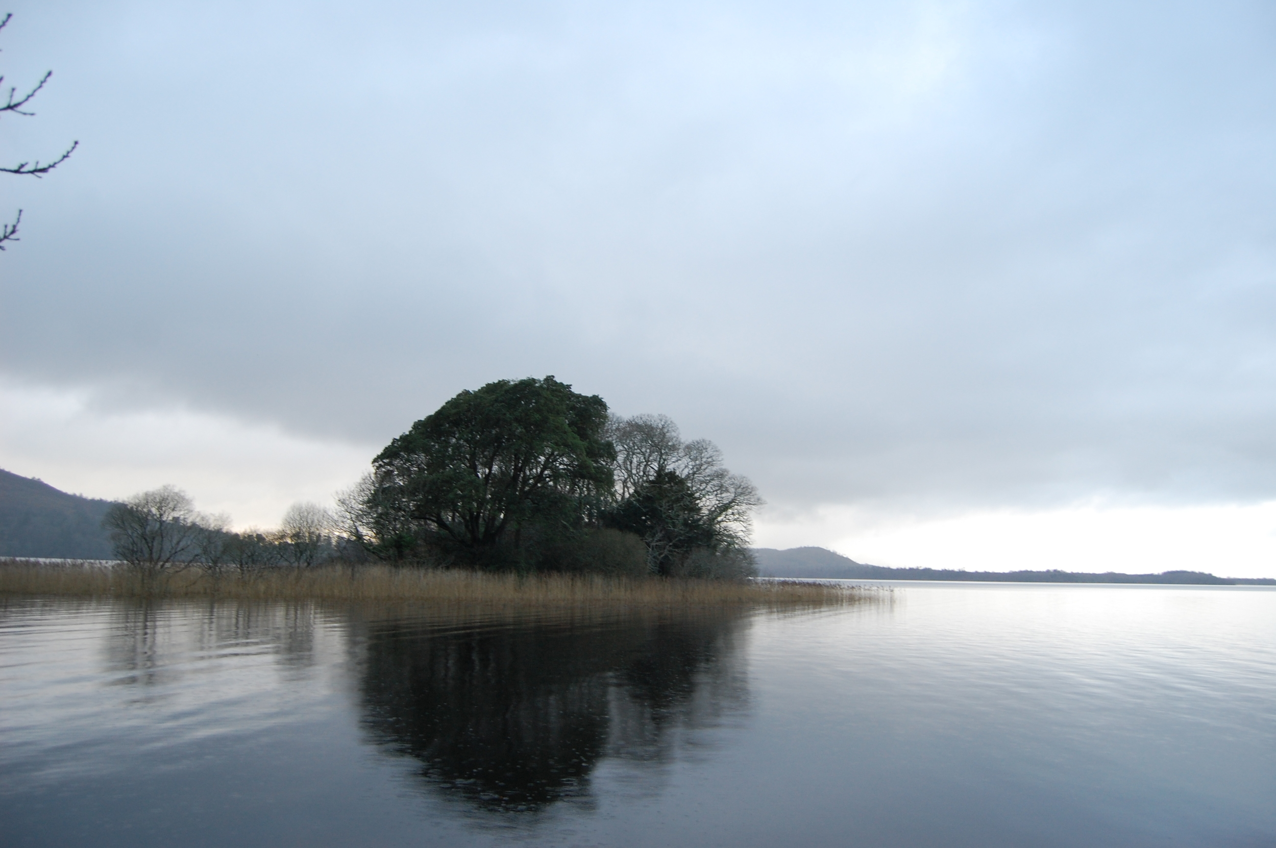
I walk to the north side of the ridge and there, right below me, is little Loch na Ciaróige, set like an inky jewel in the earth over Annagh beach on an isolated wedge of peaty coastland. In the pub that night an old islander told me he had heard much of Annagh but had never been. He wondered if he was still fit enough to make the trek.

In 2010, after the breakdown of a relationship, I started hillwalking. I remember stopping for lunch on the upper slopes on Corcóg, in Connemara, Co Galway on one of my first walks. Sitting on a saddle between two peaks, I could see nothing but mountains and valleys around me. There were no roads, cars, or houses within sight. Just by walking to this spot, I had made civilisation vanish. This was my first experience of the idea of wilderness, and I was addicted.

I went into the mountains as often as I could, and started poring over maps: was there any wilderness left in Ireland? How far could I get from houses or roads? How deep could I go into Ireland’s mountains? I was fascinated by the idea that there were still big uncivilised tracts of land out there, particularly in countries that were otherwise considered to be ‘developed’.

I found out that the remotest point in the contiguous United States is on Two Ocean Plateau in Yellowstone National Park, twenty-two miles from the nearest road as the crow flies (in practice, walking there is a seventy-mile round- trip). On the UK mainland the remotest point is between Loch Maree and Little Loch Broom in the north-west Highlands, six miles from tarmac. And in Ireland, it’s on the blanket bogs of north-west Mayo. I walked the Bangor trail there, an old livestock droving track between the tremendous Owenduff bog and the roadless Nephin Beg hills. Then I came to Achill, whose north-west tip is one of Ireland’s last slabs of wild earth.

Here I had found something – the pursuit of wildness – that I could live by, a rock — in the literal, lithic sense — on which I could ground myself and create my identity afresh. If I didn’t want just to be a scientist, I did aspire to be a hillwalker, a wild camper, an outdoorsman.

Nature gives us a foundation on which to cultivate an unshakable sense of self, and the ability to send down thick roots even if we don’t always stay still. So many roles that await graduates today seem ambiguous and disconnected, jobs that end with words like consultant, analyst, manager, advisor. But people often define themselves not by their desk job, but by what they do in nature: they’re birdwatchers, hunters, anglers, surfers, farmers, gardeners, climbers, fell runners, kayakers, beekeepers, tree climbers.

This is why I feel for fishermen who are forced to stop fishing, or turf cutters who are told to stop turf cutting. Multiplied over extensive landscapes and carried out by large populations, these activities can be ecologically destructive, but for the individual they are not only a means to survive, but one that also provides connection with the land and forms a core part of one’s identity. Ripping away part of someone’s self with the stroke of a pen always feels savage, however necessary it may sometimes be thought to be.

The descent to Loch na Ciaróige is tricky, a steep scramble through heather, ferns and hidden boulders. In summer this hill is a thick microclimate of bracken and blooming heather, the antithesis of the bog I have come from. But it is winter now: the heather bloom is gone, the bracken is rusted and dead. At the bottom I walk on small peaty cliffs above the shore where the outgoing tide has exposed a sandy beach. The seawater is transparent, and I want to go for a swim.

I walk down to the beach, but rationality nags at me: How will I dry myself after? How will I warm up at this time of year? What if, cold and wet, I get stuck out here? So I chicken out, and keeping walking west.

Long-running research in the US has investigated why people go to wild places, and how we use them to construct our identities. Studies by Jeffrey Brooks of the US Fish and Wildlife Service and Daniel Williams of the Rocky Mountain Research Station, both social scientists, provide insight into this phenomenon.

In a paper published last year, Brooks and Williams wrote that we think of the time we spend in wild places as ‘a process of building and maintaining a coherent identity narrative – a story about oneself – that structures and infuses one’s everyday life with meaning.’ ... ‘A person’s relationship with a wilderness setting ... is interconnected with that person’s whole set of relationships with other people, places, and things,’ they wrote. Back in 1990, Williams and colleagues concluded that the more time we spend in wild places, the more our reasons for going back shift from purely escapism to introspection, self awareness, and developing new skills. What we want from the time we spend in wilderness, Williams and others wrote in a 1998 paper, are stories that ultimately enrich our lives.

I continue westward, over peat hags, heather clumps, bog pools. Is this wilderness? The word has never quite fit the Gaelic lexicon, feeling more like an American construct. Besides, there are signs of dead civilisation all around me. At Annagh, there are the ruins of an old booley village, where herders would bring livestock to summer pasture, living in small stone huts. Achill was the last place in Ireland where transhumance was practiced.

There’s also a stone hut which may have been a ‘sweat house’, a type of primitive sauna for treating rheumatism. Further west there are abandoned homesteads, and a fulacht fiadh – a Bronze-Age cooking site. Most wild land in Ireland is littered with archaeology, a reminder that there were two million more people on the island in 1841, before the Great Famine, than there are today. The back of beyond is full of old ghost stories too: a group kept awake all night by horses galloping around them, girls sleeping in a hut whose dog was thrown on top of them by an unknown figure, and a woman who — haunted by something she saw — insisted on leaving this place forever. I wonder whether these might have been cautionary tales, spun to stop children venturing out here.

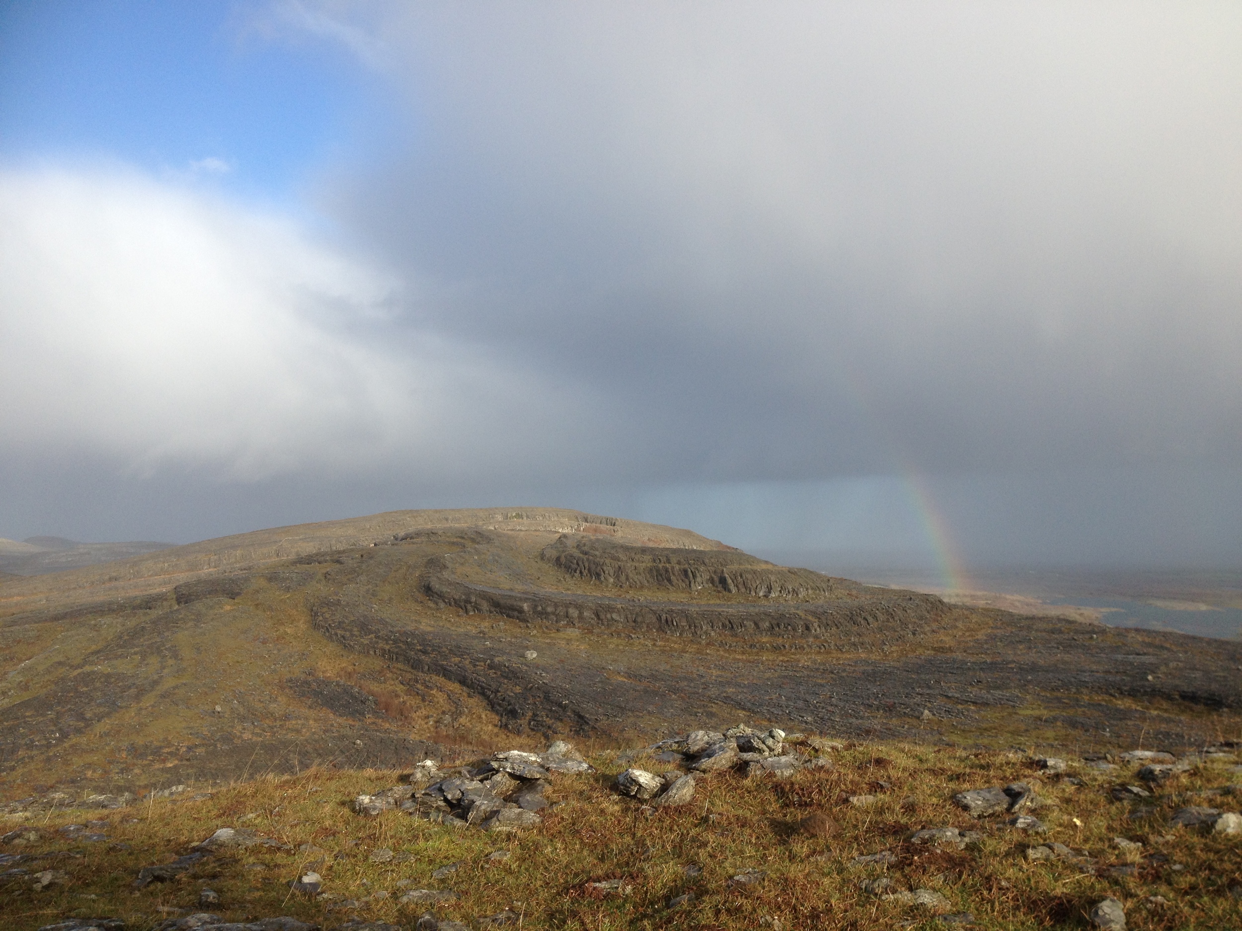
The sky is blue and bright, and I cross a stream where a lake narrows and falls into the sea, and soon I’m climbing upwards. The wind whips up, a shower passes over, and I walk out on to the precipice of Saddle Head, one hundred and twenty metres high. But this is merely a viewing platform for what is in front of me: the six hundred-metre sea cliffs of Croaghaun mountain, the tallest on the British Isles, realm of the peregrine falcon. The only way to see them is by hiking or boat.

The English journalist J Harris Stone visited here in 1906 and wrote of the ‘sheer frowning precipices, no less than two thousand feet in height, and chaotically disarranged boulders of gigantic proportions, round which the Atlantic rollers fume and smoke’. I stand gawping for twenty minutes at this two kilometre-long wall of grass and quartzite. Leaving this spot won’t be easy.

From here, if you turn and follow the cliffs inland, the land rises to a lip backed by a steep corrie wall. Walk towards the lip, climb it, and then, abruptly, at the last moment, Lough Bunafreva West is below you. This place is impossible: a blue-black, rock-rimmed tarn in the middle of the cliffs, overlooking the precipices of Saddle Head: a chaotic, tiered arrangement of the vertical.

The Irish botanist Robert Lloyd Praeger described the lough as ‘perched on the edge of the huge cliff with another cliff overhanging it — a place so lonely and sterile and primeval that one might expect to see the piast or other Irish water-monster rising from the inky depths of the tarn’. I’ll stop here for lunch; I have a long walk back ahead of me.

Our identities are intricately wrapped up in the the places we have been. The longer we remain somewhere, the more we pay attention to a place, the more it becomes a part of us.

But this doesn’t mean that brief visits to wild places are futile; the opposite often seems to me to be true. The back of beyond has become a part of my own narrative because of its wildness. Its isolation means that, precisely because few other people have been here, it effortlessly becomes part of my own story.

I giddily recall my trips here, write about this place, bring people here, study its history and wildlife and folklore. Coming here also allows me to create myself, to tentatively begin to become the person that I want to be, someone connected with wild landscapes.

Of course, people do things away from nature that give them an unshakable sense of self too: they’re teachers, doctors, actors, dancers, artists, musicians, police officers, carers. But I suspect that these roles provide a resolute sense of identity because they require us to engage face-to-face with the world, to kick disconnection in the teeth. Or they demand that we create, which means engaging deeply with ourselves.

And yet, constructing identity is about more than an individual project for laying the stonework of one’s self. Sharon Blackie wrote in the last issue of Earthlines (Issue 4, pp 40-44) that a sense of belonging to a place entails a responsibility to it; similarly, an identity based on nature compels us to protect it. Developing a sense of self based on wild places means that we actively make those places a part of who we are: we mortar them into our own identity. This obliges us to fight for them, simply because any threat to them immediately becomes a threat to our very concept of self. So what are you waiting for? Go on – get out there into the wild.

Island in the sun

Lenny Antonelli takes a spring walk on one of Connemara's less visited islands Irish Times, April 27, 2013

Inis Ní always seemed elusive to me. I had often passed the seductive signpost for the island after coming over the vast and empty Roundstone bog. Just when you think you've found the wildest coast in Connemara, there is Inis Ní, stretching further into the sea. The island's new looped walking trail seemed a good excuse to finally explore it. On a grey April day the cone of nearby Cashel Hill had emerged from the mist to dominate this bogscape. But slowly the sun came out and dissolved the cloud, turning the sky blue-bright and revealing the Twelve Bens, which dwarfed everything.

You can see why this mountain range is iconic: their clustered, alpine profile pierces the skyline from north Connemara right down to the Burren.

Inis Ní is one of the most northerly outposts of the south Connemara Gaeltacht. But in Listening to the Wind, the first of his Connemara trilogy of books, Tim Robinson says use of the language has declined to the point that it is no longer a bona fide Irish-speaking community. The island's name, he says, might relate to the surname Ó Niadh.

The trail followed a quiet road past granite walls caked in lichen and moss, old peatland inundated by the tides, and patches of earth blackened by the burning of gorse. There were signs of modern Ireland too, like obtrusive bungalows and unfinished buildings, but the deeper into Inis Ní you go the further you feel from 21st century Ireland.

The trail runs down the west side of the island, looking over the water to sandy Gorteen Bay, Errisbeg Hill and the village of Roundstone that Scottish engineer Alexander Nimmo founded in the 1820s.

According to Tim Robinson, the island's tradition says that local landlord Patrick Blake evicted what few tenants remained after the famine and turned Inis Ní into a sheep ranch. This was before the first bridge was built, when the island could only be reached by scrambling across rocks at low tide. But when the ranch failed Blake brought new settlers in from nearby Carna.

I walked down to a pier overlooking Roundstone Bay, and stopped to explore the tidepools. These habitats are our own miniature coral reefs, rich in biodversity. In just one I counted beadlet anemones, polychaete worms, a rock goby, tiny crustaceans, limpets, dog whelks, and all manner of algae and lichens.

In The Story of Connemara, Patricia Kilroy writes that a Mrs Faherty of Inis Ní, who used to walk for miles carrying a basket of fish on her back to meet the train to Galway, had recalled, "the joy of welcoming the travelling fiddler, the dancing in a cottage that night, followed the next night by crossroads dancing — for no house could contain the crowds. In fact, most elderly Connemara people remembered the happiness of their youth rather than the hardship."

The sun was, the coconut scent of gorse filled the air and cattle dozed on the grass — this felt like the first day of spring.  I left the marked trail and took a cul-de-sac towards the island's barren southern tip, where a cacophony of birdsong emanated from the heath.  Then I made my way back to the marked route and followed it past the ruined chapel of St Mathias with its graveyard, past another small harbour, and back towards mainland Connemara.

Inis Ní loop, Co Galway

Map:  OSI Discovery Series Sheet 44 or Tim Robinson's map of Connemara published by Folding Landscapes. Trail map at irishtrails.ie.

Suitability: Easy. Minor roads & tracks.

Start & finish:  The turn for Inis Ní/Inishnee is off the R341 2km north-east of Roundstone. Cross the bridge and the trailhead is on your left.

Distance & time: Inis Ní Loop is 6km (two hours). My extension added an extra 3km (one hour).

Services: Roundstone, Clifden


Dawdling along the Dodder

Irish Times, April 13, 2013 Lenny Antonelli walks the Dodder river through Dublin

By the time they reach cities, most rivers have deposited their personality: they're flat, dull, dirty. But the Dodder is different. Flowing from Kippure mountain to the Liffey, it's a river rich in whitewater and wildlife.

I set out from Ringsend, once separated from the city by the Dodder's sprawling estuary, until the river was brought under control and the marshlands were reclaimed in the 18th century.

But in the years that followed this area was lawless, a refuge for outlaws that was known for its burglaries and highway robberies, according to Weston St John Joyce's 1912 book The Neighbourhood of Dublin.

A little egret was foraging in the shallows of the river at Ringsend. Once rare in Ireland, these small herons are now common in coastal counties.  When breeding they develop extravagant plumage, which was once so popular for decorating hats that it threatened the species.

Walking the Dodder gives you an alternative view of the city, showing you islands of countryside in the suburbs, and fragments of architecture that remind you Dublin was once built around its rivers as much as its roads.

But this was the wrong time to walk the Dodder. It had flooded after heavy rain and deposited all manner of rubbish along its banks. But every year the group Dodder Action undertakes a big clean up of the river, restoring it to wildness.

Snow started falling, but anglers braved frigid temperatures on the riverbank. After Donnybrook and Clonskeagh, the riverside paths wind through parklands, passing weirs, waterfalls and rapids.

A watercolour painting titled 'On the River Dodder near Rathgar' by the 18th and 19th century artist John Henry Campbell shows a dramatic country scene: tall trees looking over a waterfall, a farmstead on the riverbank, the Dublin Mountains looming behind.

Near Rathfarnham a grey heron, surely the most zen of all birds, stood motionless on a branch high above the river. As passerby told me this was also a great place to see foxes, and that there were mandarin ducks on this stretch of the river too. And a minute later, a group of strikingly coloured males — white, brown, blue, pine green and orange — flew past. At Bushy Park another man pointed out the best spots to see kingfishers and dippers.

Then near Firhouse a flock of starlings — called a murmuration — floated in unison across the dusky sky, creating all manner of shapes that dissolved as quickly as they formed.

Starlings form these huge groupings to avoid predators, keep warm and exchange information such as where good feeding spots are, according to the Royal Society for the Protection of Birds.

In his poem 'Down by the Dodder', the Rev Matthew Russell, founder of the Irish Monthly, confessed that he had spent too long living near the river without exploring it.

"And so from life's loud, dusty road / A somewhat jaded plodder," he wrote, "I steal to this serene abode / And thee suburban Dodder!"

The Dodder, Ringsend to Firhouse, Dublin

Start: Ringsend Bridge

Finish: Dodder Valley Linear Park, Firhouse Road. Bus 49 heads to Pearse St from stop 3004 on nearby Ballycullen Ave.

Route: There are paths near the Dodder most of the way, but for some stretches you must detour away from the river. Bring any detailed street map to find your way.

Suitability: Easy, but the river rises quickly and floods during heavy rain so avoid it at these times. Walk on designated paths rather than on the bank itself. Bring walking footwear, rain gear, snacks, water.

Time: A leisurely five hours

Distance: Approximately 15km


Ireland's last wilderness

Lenny Antonelli take a ten hour hike through "the very loneliest place in Ireland"  Outsider magazine, Spring 2013

Unlike most things, it started in a pub on Achill in January.  "How's Galway this weather?" one of the locals asked me.

"Ah fairly quiet," I said. He burst into laughter. If Galway was quiet in the dead of winter, what was Achill?

But the island is still a bustling metropolis compared to some parts of Mayo, he insisted. "Ever been to Carrowteige in north Mayo?" he asked. "It's sort of like an Alaskan outpost."

"Or have you heard of that aul' Bangor Trail? I was camping out there for a few days and had to climb a mountain just to get phone coverage to call my daughter and tell her I was still alive."

His friend piped up: "Sure what you be doing going out into all that aul' wilderness?"

We don't really do wilderness in Ireland. Stand at the top of Carrauntoohil and you're still only a couple miles from the nearest road.

But Mayo's a bit different. The road network seems sparser, and doesn't stretch to every last corner. The county boasts some of Ireland's wildest and remotest spots — like the towering cliffs of Achill's western tip, or the epic crags and isolated beaches hidden by the mountains of Mweelrea.

And then there's the Bangor Trail. An ancient route through the Nephin Beg hills of north west Mayo, the trail was once used to bring livestock across this desolate landscape.

Scour a map of Ireland for a wild, roadless tract of land and you'll be drawn to the Nephin Begs — the only big range of hills we didn't drive a road through.

"Indeed the Nephinbeg range of mountains is I think the very loneliest place in this country, for the hills themselves are encircled by this vast area of trackless bog,"  Irish naturalist Robert Lloyd Praeger wrote in his 1937 book The Way That I Went —  his epic account of five years spent exploring the country.

"Where else even in Ireland will you find 200 square miles which is houseless and roadless?" he wrote. "I confess I find such a place not lonely or depressing but inspiriting. You are thrown at the same time back upon yourself and forward against the mystery and majesty of nature and you may feel dimly something of your own littleness and your own greatness."

The trail — not an official national waymarked way — starts in Newport, but the first half is mostly on road. The real Bangor Trail starts from the Brogan Carroll bothy at Letterkeen, a fairly remote mountain shelter. From here, it's 24km of wild terrain before you reach the village of Bangor Erris.

I hit the trail with local mountain guide Barry Murphy of Tourism Pure Walking.

Leaving the bothy, we cross a stream and skirt the edge of a vast conifer plantation. Barry squats down to study something beside the stream. "Otter scat," he says. "Smells like white wine."

After a few miles the plantation recedes into the background, and with it goes the last sign of modern civilisation we'll see for hours.

Ravens circle over Nephin Beg mountain up ahead as we hop streams along the trail. Though the word trail itself is a bit a euphemism: the way varies from rock to dirt to bog, most of it sopping wet.

We hike up to the Scardaun Loughs, two lakes plucked out by the ice in the U-shaped valley between 627m Nephin Beg and 721m Slieve Carr.

Slieve Carr is the highest mountain in the range. Hikers regard it as Ireland's remotest summit —it demands a serious trek just to get to its base.

The mountain was said to be the home of Daithí Bán, an 18th century highwayman who would stalk and attack travellers from the mountain. Another tale tells of a traveler who hid in the rotting corpse of a horse to avoid thieves out here.

Back on the trail, we cross a gully that shelters a lone, wind-twisted oak tree — the only native tree we see all day. Ruins of old farmsteads on the way echo a time when this was a busy trade route.

Skirting the western flank of Slieve Carr, you realise just how isolated you are: to the north there's 15km of tough terrain to Bangor Erris, to the east the mountains loom overhead with vast forestry beyond, and to the west stretches the endless Owenduff bog. Once you start the trail, there's no easy way out.

Scots pine once blanketed this landscape, but Ireland's climate got wetter about 4,000 years ago. Rain washed minerals down through the soil, forming an impermeable layer and water-logging the land. Mosses took over, the forest died and the vast bog formed. Out here, it's still forming.

Barry points to an old trail that stretches west across the bog. He was advised never to take that route "for fear of disappearing into the bog."

The biggest mistake you could make out here would be to take a shortcut across the bog — the trail has been etched out by thousands of feet over the centuries into a perfect route: low enough to avoid unnecessary climbing, but high enough to avoid deep bog.

Even on the trail we frequently plunge shin-deep into bog, but Barry insists he's never seen it this dry before.

We follow the winding course of a nameless river that emerges into the desolate Tarsaghaunmore valley.

The salmon-rich Tarsaghaunmore and Owenduff rivers that drain the vast bog are some of western Europe's last untouched waterways, rising in remote corners of the Nephin Begs and flowing straight across the bog and into the Atlantic, bypassing civilisation.

The light fades as we eat dinner on the water's edge. A farmhouse in the distance is the first sign of modern civilisation we've seen since morning.

The trail meanders over a range of low hills towards Bangor Erris for the last five miles. We put our headlamps on as night falls, but lose the trail and have to fight our way through thick scrub towards the lights in the distance. The last few miles take an eternity.

My right ankle seizes up, and I limp on through the dark. We find the trail again and — finally — stumble onto a boreen just outside the village. We've been hiking for ten hours. Looking back towards the trail, and towards the lonely Nephin Beg hills, all I can see is darkness.

Bangor Trail: Tips

Set aside a good 12 hours to hike the entire trial, and prepare to finish in the dark — bring headlamps or torches.

Tackle it after a spell of dry weather — it's extremely wet at the best of times. Not all streams on the way have bridges, so some could be very dangerous to cross after heavy rainfall.

Prepare for midges in summer — bring insect repellant.

There are shorter looped hikes in the area: the Letterkeen loop, Bothy loop and Lough Avoher loop all start at the Brogan Carroll bothy and range from 6km to 12km (www.irishtrails.ie).

Only experienced hikers who know how to use a map and compass should tackle the trail. If you don't feel experienced enough, hire a guide.

Navigation skills are crucial as the trail can be hard to follow, and marking is scarce. At grid reference F889131, make sure to turn left to follow the stream as directed by the marker, rather than following the track off to the right.

Bring good waterproof boots, rain gear, gaiters, warm clothing, lots of food and water, map and compass.

The section of the trail described, from the Brogan Carroll bothy to Bangor Erris, is covered by Ordnance Survey Ireland Discovery Series map 23. The section from Newport to the bothy is covered by map 31 of the same series.

To get to Brogan Carroll bothy, leave Newport on the N59 towards Achill but turn right after 1km towards L Feeagh/Letterkeen. After about 12km, turn left just after a bridge onto a forestry road. Follow this road for 1km to the bothy.

Ballycroy National Pak

Much of the trail runs through Ballycroy National Park, established in 1998. The park comprises 11,000 acres of blanket bog and mountain terrain.The vast Owenduff bog is one of the last intact active blanket bog systems in western Europe.

Other habitats in the park include alpine heath, upland grassland, wet and dry heath, lakes and river catchments. Animals here include mountain hare, otter, fox, badger, pygmy shrew, and bats as well as birds of prey such as kestrels, sparrowhawks and peregrine falcon. Other important bird species in the park include Greenland and white-fronted geese, and golden plover. Some of the most common bog plants include sphagnum mosses, black bog rush, purple moor grass and bog cotton.

A visitor's centre with tearooms is open during the summer in the village of Ballycroy on the N59 between Mulranny and Bangor Erris. For more information, see www.ballycroynationalpark.ie.

Stay on the Bangor Trail

This summer Mountain Meitheal volunteers constructed an Adirondack-style shelter for campers along the trail, on Coillte lands near Letterkeen wood at grid reference F938 073. The hut contains sleeping room for up to 6 people and is designed to allow people to camp without a tent (though you'll still need to bring a sleeping bag plus all your other camping supplies). It's the first in a planned series of designated camping areas as part of the Wild Nephin project — a joint initiative project between Coillte and the Natonal Parks and Wildlife Service to set aside the area as Ireland's first designated national wilderness. The construction of the hut also celebrates ten years of Mountain Meitheal.


High in the clouds in Co Mayo

Exploring the river banks and mountain passes on the Western Way

Irish Times, 14 March 2013

Mist can play tricks with mountains. Walking on the Western Way on a March morning, cloud had covered the body of Devilsmother mountain but left its summit exposed. Wrapped in cloud, you forget the mountains are there until you see a detached peak far up in the sky, higher than it ever looked before. But more often the opposite occurs: mist rubs out the tops, so you forget where the summits are and imagine you’re walking under the Alps or the Andes. The Western Way winds through Connemara and west Mayo, and I spent two days ambling on it north of Leenane. From Aasleagh waterfall, the trail heads under Devilsmother along the sandy, salmon-rich river Erriff. I met a farmer here with his sheepdog who told me he was sick of wearing wellies and asked me to recommend a brand of walking boots. Wagtails jumped between rocks on the river.

The trail leaves the waterway and enters Tawnyard forest. As I turned one corner here, frogs bounded chaotically in every direction: I had stumbled uninvited into their annual orgy. The common frog spawns in early spring – the male croaks to lure a female, then piggy-backs on her until fertilisation. But only a tiny fraction of the fertilised eggs become adults. Gradually the tadpole’s gills and tail disappear, lungs and legs form and in summer the froglet leaves the water.

I counted 22 frogs in a single puddle, but it was drying out and frogspawn lay desiccating in the mud. But most had wisely chosen deep ditches, where the males were croaking loudly.

The trail emerges to a platform overlooking Lough Tawnyard encircled by mountains, then joins a quiet stretch of twisting road cut into the mountainside. Ravens clucked over the precipices.

Walkers have two options after Sheeffry Bridge: follow the road for 5km to Drummin or head over a high pass in the hills. The latter is only for experienced hillwalkers – there is no path, only sparse waymarkers on the open mountain. The mountain route climbs to a stone wall on the hillside and follows this, then turns off right and ascends to a flat valley.

The sky was blue and bright, and I could hear the guttural and exotic sounds of a farmer commanding his sheepdog in the distance. The trail follows a stream over boggy ground up to the east side of a saddle above ice-scooped Lough Lugacolliwee. Don’t head up here if visibility is poor, and stick with the marked route - there are cliffs on the north side of the saddle, but the trail takes a safe route down to the east of the lake. Care is needed though as this section is steep and wet.

The trail follows the lakeshore and emerges to a road a little west of Drummin.

But I didn’t get that far: I had no transport from Drummin, so on my second morning on this intoxicating stretch of the Western Way, I sat looking over Lough Lugacolliwee to Croagh Patrick, then got up and started the long walk back to Aasleagh.

Map: OSI Discovery Series, 37

and 38. These may show old trail route, latest route at irishtrails.ie.

Start: Aasleagh Falls, just off the N59 northeast of

Leenane.

Finish: For Drummin, turn off the N59 about between Leenane and Westport at Liscarney. Turn at Drummin church for shop/pub.

Suitability: Erriff and Tawnyard forest are easy but remote. Lough Lugacolliwee route is a moderate mountain walk for experienced hillwalkers.

Take a walk in the woods

Irish Times, Saturday March 2, 2013

LENNY ANTONELLI visits a forest park on the shores of the Shannon

The Japanese term shinrin-yoku means “forest bathing”, or immersing yourself in the woods. The country even designates forest bathing sites to promote relaxation and health.

If you can’t make it to Japan, you could try Portumna. The Galway town’s Irish name, Port Omna, means “landing place of the oak”, but its 450 hectare forest park is dominated by mature conifers. We set out from Portumna marina, with no real plan but to see where the park’s maze of trails would take us.  Portumna Castle watches over this side of the park. It was built in the early 17th century by the earl Richard Burke, a Catholic who fought for the English and was knighted for bravery at the Battle of Kinsale. Living however in his residence near London, he may have never even seen Portumna Castle. A fire gutted the residence in 1826. The state bought the demesne in 1948 before the OPW started restoring the castle.

Coillte has felled mature spruce trees in the east of the park and replaced them with native oak, ash and hazel. We followed trails here to the shores of Lough Derg, where a cormorant colony had blackened the trees of an island offshore.

We passed open grassland, mirror-like forest ponds and a pine grove with a grassy floor smooth enough for a game of woodland golf. Then we went west through rows of scots pine. This species was once common in Ireland, but is thought to have become extinct before being reintroduced from Scotland. The park is home to more exotic conifers too, like monterey pine and monterey cypress, cedar of lebanon, and western red cedar.

Japanese research suggests that “forest bathing” reduces blood pressure and concentrations of stress hormones and even helps boost immunity. Studies suggest that phytoncides – aromatic compounds released by plants – could be directly responsible for some of these effects. We were certainly getting our fill. Suddenly there was a scramble from the undergrowth; a female fallow deer was standing motionless a few metres from the trail. She soon bolted, though, abandoning her plan to remain silent and still. I grew up in suburban Galway and as a teenager, coming to Portumna Forest Park for the first time was a revelation – it’s hard not to see deer here. Fallow are the most widespread species in Ireland. The bucks are known for their large palmate antlers. The Normans introduced them to Ireland in the 13th century and there are over 200 in Portumna Forest Park. This wood is a stronghold for red squirrels too.

We passed a many-limbed oak tree in the quiet Bonaveen section and before I knew it, my walking buddy was working her way up the trunk. I scrambled behind her out on a thick limb. We were only a few feet up, but it was enough to look over the lake and linger.

On our way back, we followed a trail through the deepest section of forest to a beech grove, also known as the ladies tea garden. “We can’t be that far away from the castle now if this is where the ladies came for tea,” my companion said wryly, as we made our way back towards the marina.

PORTUMNA FOREST PARK:

Start and finish:Portumna marina, Portumna, Co Galway. Main entrance on R352 was closed for maintenance at the time, but you can enter at marina.

Time/distance:A very slow 12km/ hours for me, but any length is possible.

Suitability:Easy; rough trails through the woods, plus buggy and wheelchair friendly paths and mountain bike trails.

Map:OSI Discovery series, sheet 53. Map, trails and info at coillteoutdoors.ie

The scenic way to Shannon

Irish Times, Saturday 9 February 2013

LENNY ANTONELLI walks the Royal Canal on the Meath-Kildare border

The Royal Canal was raised in the shadow of its big brother. In the 1750s the idea of a waterway linking Dublin to the north Shannon was rejected, and instead the more southerly Grand Canal was built.

In the 1780s a director of the Grand Canal Company quit to build a rival waterway. But the route of the Royal Canal wasn’t precisely planned, the project amassed huge debts, and the founding company was ultimately dissolved. The Royal Canal finally met the Shannon in 1817, costing far more than its rival. It never saw as much traffic either.

I followed the towpath east from Blackshade Bridge, Co Meath on a cold January afternoon, the sky coated with cloud too thin to dull the clear winter light. The canal was frozen shut in parts, while in places it seemed ice-free until I got close enough to see a film of cellophane-thin ice.

I day-dreamed of skating down the canal rather than walking beside it.

The canal bridged the Boyne on a limestone aqueduct, then passed under the Ribbontail footbridge, built to bring Massgoers to the church in Longwood. It may have been named after the Ribbonmen, a secret agrarian society that fought for farm workers’ rights.

In his book Irish Popular Superstitions, William Wilde described the departing journey of Longford emigrants on Royal Canal packet-boats.

“Their friends followed for a considerable distance, many, brimful of whisky as well as grief, crowding upon the bridges, and sometimes pulling the boat to the brink by the tow-rope, for the purpose of sending a message to one of their transatlantic friends,” he wrote. “All gradually fell back, except one very old woman, who, with her grey elf-locks streaming in the wind . . . ran after the vessel which contained her only son.” The canal welds human and natural engineering together. It’s layered with wildlife habitats but never too wild. Instead human design makes it seem sedate: the flat level, the straight channel, all those right angles.

The drone from the nearby M4 was constant, but it just made the canal seem more secret.

The Dublin-Sligo railway line follows the canal too.The Midland Great Western Railway Company bought the whole waterway in 1845 to build a track on the land beside it. But the arrival of trains to Ireland undercut the canal boats – even the light “fly boats” took eight hours to ferry passengers from Dublin to Mullingar.

CIÉ closed the Royal Canal in 1961. The western end dried up, locks decayed, and there were even plans to build a motorway on the Dublin city section. But campaigners fought to save to it, and in 2010 the full canal reopened. The towpath is now a long-distance walking trail, the Royal Canal Way, running from Dublin to the Shannon.

I passed Furey’s pub at Moyvalley and walked into Enfield in declining light. But you don’t have to follow my route to the letter: the train stops plenty between Dublin and Enfield, making day-walks between stations easy.

ROYAL CANAL WAY, BLACKSHADE BRIDGE TO ENFIELD

Trail Start at Blackshade Bridge, Co Meath, near M4. Finish at Enfield. At Moyvalley the trail crosses a busy road, and some steep road bridges are hard to see over. Seewaterwaysireland.orgfor canal sections. Three hours, 12.5km

Map irishtrails.ie. OSI Disc Series sheet 49.

Wildest Dublin

Irish Times, 5 January, 2013 Lenny Antonelli walks the Dublin Mountains Way, one of Ireland's newest long-distance trails

I went to Dublin seeking wild landscapes, not really expecting to find any. Living on the west coast I usually don’t travel far for this sort of thing. Going to Dublin to find mountains felt incongruous. Zig-zagging over the hills from Tallaght to Shankill, the Dublin Mountains Way is two years old. I started from the trailhead at Seán Walsh Park, Tallaght, aiming to make Glencullen by sunset. The trail skirted housing estates, then dropped me into comparative wilderness around the Bohernabreena reservoir, where the river Dodder was damned in the 1880s and wooded hills fall to the lakeshore.

This valley is also home to orchid-rich grassland and petrifying springs, where lime-rich water rises from the ground and deposits calcium carbonate in a white, crunchy coating.

The trail brought me into the hills, looking over to lime and rust-coloured slopes on Seahan and Corrig mountains. Walkers need to be cautious as this section is on narrow, windy roads.

I expected Celtic Tiger mansions up here and there were some. But it was mostly old stone cottages, hay sheds, farm yards and signs warning that dogs worrying sheep would be shot.

This valley – Gleann na Smól, glen of the thrushes – was one of the last places in which the Irish language survived near Dublin.

Heavy mist pressed down on the hills as I climbed. And though I couldn’t see them, I was surrounded by mountains.

The trail entered the Featherbed forest, but the name felt euphemistic as it crossed felled planation. I felt like a lone survivor in the aftermath of some brutal apocalypse, surveying a landscape of decaying tree stumps, black pools, churned peat and a few limbless trees. It reminded me of the writer Tim Robinson’s description of clear-felled forest in Connemara as “frozen at a moment of maximum horror”.

But soon I entered the forest at Cruagh, passing a mossy stone bearing an inscription to the naturalist HC Hart, who in 1886 bet a colleague that he could walk the 111km from Terenure to the summit of Lugnaquilla in Wicklow and back within 24 hours.

He won, returning to Terenure with 10 minutes to spare. The trail followed rows of mature spruce trees, heather, mosses, and flowering gorse.

I went up Tibradden Mountain and towards the summit of Two Rock, the way’s highest point. Writer and nationalist Stephen Gwynn described this area as “bare and lonely, as devoid of any suggestion of a great city’s nearness as even Connemara could show”. This is what I had come looking for, but I could only see a few metres of the trail rising into the clouds ahead of me.

Soon a gust of wind blew off the clouds to reveal Fairy Castle, Two Rock’s summit tomb, and the orange glow of the city below.

The trail brought me towards the huge transmitters at Three Rock. Writing in 1780, the artist Gabriel Beranger reckoned the mountain’s distinctive rock clusters were altars built to offer sacrifices. They are, in fact, natural granite formations.

But I was in trouble: the walk had taken longer than planned and the sky was blackening, so I donned a headlamp and high-vis jacket to descend Ticknock forest in the dark. The final stretch into Glencullen on country roads in the dark was the most treacherous bit of my walk – without a headlamp I’d have been in serious trouble.

The lesson? Walking from Tallaght to Glencullen is probably too much at this time of year – if you want to walk this route in winter, tackle it over multiple days, or just pick a sub-section.

Dublin Mountains Way

Map : Get trail maps from dublinmountains.ie(the DMW route can change). OSI Discovery Series Map 50 covers the area but shows an old DMW route. East West Mapping also publishes Dublin Mountains map.

Start : DMW trailhead in Seán Walsh Park off Kiltipper Road, a short walk from the Tallaght Luas stop. Or start anywhere along the route.

Finish : Johnny Foxes pub, Glencullen.

Time and distance : Tallaght to Glencullen is 20 miles with lots of ascending. Seven to 10 hours.

Route : Walking Tallaght-Glencullen in daylight during winter is a big challenge. Suitability: Bring food, water, rain gear and warm clothes, hiking boots, map, compass, high vis clothing and a torch/head lamp.

Take a walk on the Grand side

Irish Times, 15 December 2012

LENNY ANTONELLI walks a quiet section of the Grand Canal in Kildare

The Grand Canal Way is a rarity in Ireland: a long-distance walk that’s almost entirely off-road, stretching from Adamstown in west Dublin to Shannon Harbour, Co Offaly.

The section between Hazelhatch and Sallins is a perfect microcosm of it – a half day’s walk between two towns serviced by a railway whose own history is entangled in that of the canal.

I set out from Hazelhatch, where houseboats line the channel. This must be Dublin’s most chaotic and inspiriting row of homes: the barges are cream, red and highlighter blue, fat and slim, tall and squat. The towpath is decorated with bicycles, tables, old kayaks, wheelie bins, solar panels and wooden sculptures. Smoke rises from their chimneys, but nobody emerges from below deck, so I walk on.

Work began on the Grand Canal in 1756 in Clondalkin. But progress was slow, and it took more than two decades before the 20km channel to Sallins was open. Further west, the immense Bog of Allen almost sunk the project when clay walls built to support it failed. The Grand Canal finally reached the Shannon in 1803, but the age of fast rail travel was looming.

For those who normally walk the mountains or coast, the canal is an entirely different creature. While hillwalking is adventurous, canal-walking is ponderous – you needn’t worry about navigation or the terrain here, the towpath just carries you endlessly forwards. But our canals play a crucial ecological role, linking up rivers and lakes that would otherwise be isolated. And their landscape makes you pay attention for its subtler rewards, like a moorhen hiding in the sedges, or bubbles breaking on the water’s surface, perhaps released by a tench eating grubs on the floor of the canal.

Like a forgotten thoroughfare it sneaks behind fields and country estates. It’s hidden from Kildare’s modern commuter towns, and has an architecture all of its own. I passed steep stone bridges, derelict lock-keeper’s cottages, and an old canal-side church and school at Ardclough. I walked by the old Lyons demesne, with its immense Georgian manor, and Oughterard, where Arthur Guinness is buried and Daniel O’Connell killed John D’Esterre in a pistol duel in 1815. Bring a map though: often these features are behind high walls or rows of ivy-wrapped trees.

About half way to Sallins, the light started to disintegrate. Colour drained from the landscape, leaving only the black trees and the shadows they cast on the inky water. Walking in the half-light was thrilling, though, and dead silent except when my presence sent terrified birds screaming from the trees.

Soon I passed under the railway bridge just before Sallins. The Grand Canal Company fought the building of the railways, and this bridge proved pivotal: once the Great Southern and Western Railway Company won the right to bridge the canal in the 1840s, the rail network could stretch out to Cork, Limerick and Galway. Just two decades later, the mass transport of people and goods on the canal was finished.

WALKS THE GRAND CANAL WAY

Map : OSI, Discovery Series, Sheets 49 and 50. Downloadable maps of the Grand Canal Way at irishtrails.ie(see also for train times).

Start : Hazlehatch Bridge, 600m from Hazelhatch and Celbridge rail station.

Finish : Trail ends at Sallins.

Time and distance : 12.6km. Takes four hours if you want to explore slowly.

Suitability : Easy. Bring food, water and warm, waterproof clothes and footwear.

Rail services: On the Dublin-Kildare line, with trains leaving Heuston station frequently.